Geology by Lightplane
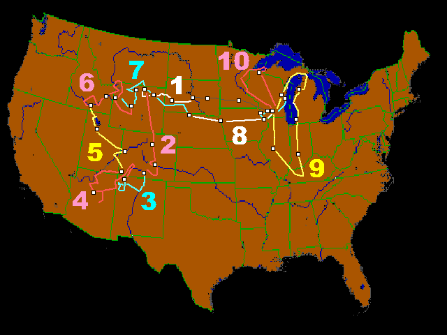
KEY TO INDEX MAP IS LOCATED BELOW.
- 1. Badlands, Black Hills, Devils Tower, Eastern Bighorn Mountains
- 2. Horse Tooth Reservoir, Spanish Peaks, Great Sand Dunes National Monument
- 3. Rio Grande, Jemez Mountains, San Juan Basin, Shiprock
- 4. San Juan Mountains, Craters, Sinkholes, Colorado and San Juan Rivers
- 5. Arches National Park, Salt Lake, Bonneville Beaches
- 6. Craters of the Moon, Yellowstone Park, Jackson Hole, Glaciers of the Wind River Mountains
- 7. Owl Creek Mountains, Sheep Mountain, Bighorn Basin, Bighorn Mountains
- 8. Nebraska Sandhills, Missouri Valley Loess, Mississippi River
- 9. Strip Mines, Sinkholes, Limestone Quarries, Lake Michigan Shoreline
- 10. Glacial Landscapes, Apostle Islands, Long Island of Chequamegon Bay
- 11. Glacial Features in the Midwest
- 12. Rivers in the Midwest
- 13. Floods and Tornados in Wisconsin
- 14. Wisconsin's Baraboo Syncline
- 15. Rivers That Cut Through Mountains: Evidence for Superimposed Stream Systems in the Rockies
- AOPA Magazine Article on the 1966 Western Flight
Detailed 2000-pixel-wide JPEG versions of these photos (averaging 1MB in size and suitable for video projection or for slides) can be down-loaded individually by photograph number from the FTP site listed below. First make a list of the identity numbers of the pictures you want. At the FTP site, those using a Mozilla Firefox Web Browser can click on the photograph number in order to load the photo to your screen; then right-click your screen to "Save the image as...." Click on "Back" to load another image. (The Microsoft Browser has a somewhat different procedure for getting and saving the file.) Do not forget to take a copy of 00readme.txt, an ASCII file that contains all the photograph captions. Go to FTP site for 2000-pixel-wide versions now.
This site is no longer being actively maintained. You may use the pictures contained here giving credit to Louis J. Maher, Jr.
Copyright © 2001-2004 Louis J. Maher, Jr.