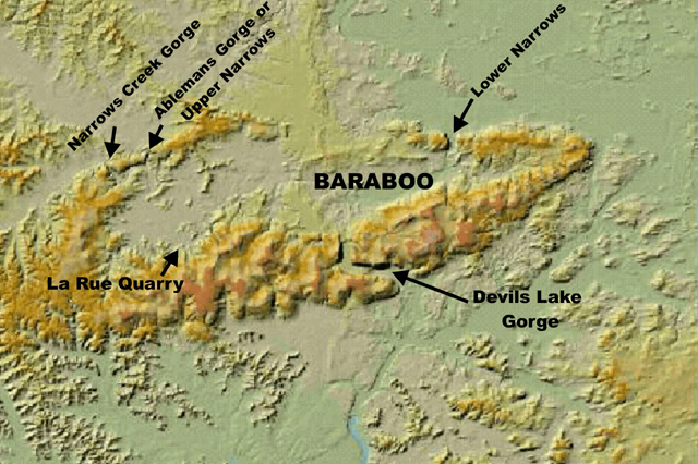
barabovc.jpg: Digital Terrain Model of the Baraboo Syncline showing the locations of some of the sites shown in the photos.
14. Wisconsin's Baraboo Syncline
barabovc.jpg: Digital Terrain Model of the Baraboo Syncline showing the locations of some of the sites shown in the photos.
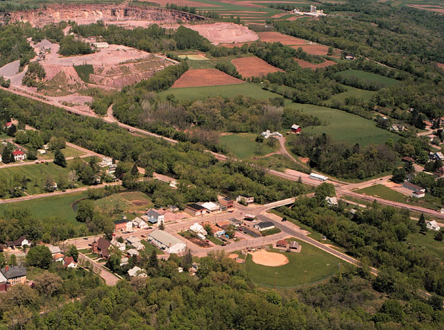
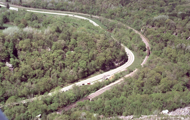
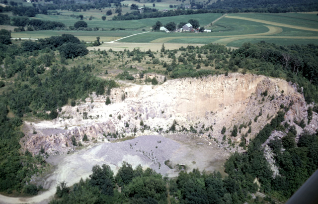
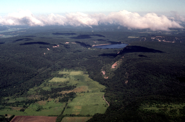
434-11: Rock Springs, WI at the southern end of Ableman Gorge on the north limb of the Baraboo Syncline. The Pink Lady quarry at the upper left of the photo produces quartzite that is used for ballast between railroad ties. The Chicago and Northwestern Railroad parallels the Baraboo River that cuts diagonally across the photo. (9May99)
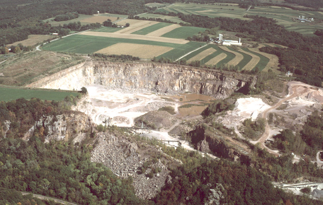
322-32: Pink Lady Quarry at Ableman Gorge north of Rock Springs, WI. View to the northeast. The rock mined is the Precambrian Baraboo quartzite, and it is used for railroad ballast. (15Oct86)
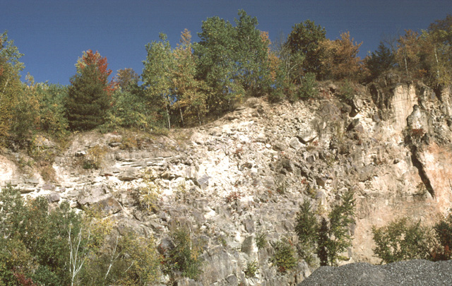
434-17: Pink Lady Quarry north of Rock Springs, WI. View to the north. The east/west-trending Baraboo Quartzite (Precambrian) of the north limb of the Baraboo Syncline is vertical at this location, and the strike is almost parallel to the north quarry wall. The quartzite is unconformably overlain by marine sandstone of Upper Cambrian age; it is the darker brown unit under the green vegetation. When the Cambrian seas reached this area, the quartzite formed a linear ridge that was progressively submerged while also being eroded by the waves; rounded pebbles and cobbles form coarse facies in the Cambrian sandstone formation. Today the quartzite is broken up for use as ballast between railroad ties. (9May99)
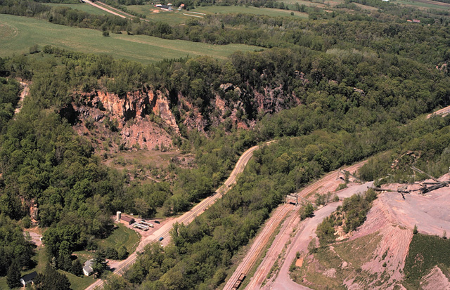
434-12: Ableman Gorge just north of Rock Springs, WI. View to the NNW. State Hy 136 runs through the gorge parallel to the Baraboo River and the Chicago and Northwestern Railroad. A part of the Pink Lady Quarry is at the right. On the left are older abandoned quarries in the vertical layers of the Baraboo Quartzite on the northern limb of the Baraboo Syncline. The quartzite is unconformably overlain by horizontal Cambrian sandstone. The two stainless-steel tank trucks to the left of the highway in the foreground are filled with spring water for commercial sale. (9May99)
371-21: Ableman Gorge north of Rock Springs, WI. View to the south. The Pink Lady Quarry is at the left. Van Hise Rock is near the bend of the highway in the foreground. The site is on the north limb of the Baraboo Syncline. The Precambrian Baraboo quartzite strikes east/west and is vertical. The upland is composed of horizontal Cambrian sandstone. (6Apr90)
430-21: Ableman Gorge north of Rock Springs, WI. The Pink Lady Quarry is in the left foreground. View is to the southwest approximately parallel to the local strike of the Baraboo quartzite. (10Apr98)
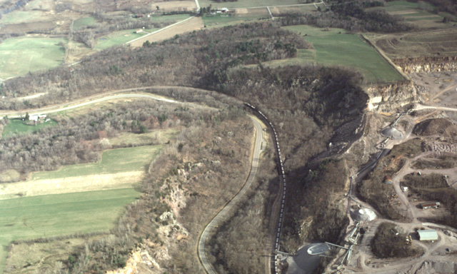
430-26: Ableman Gorge north of Rock Springs, WI. This is the Upper Narrows of the Baraboo syncline. View is to the north. The train is loading broken quartzite from the Pink Lady quarry. (10Apr98)
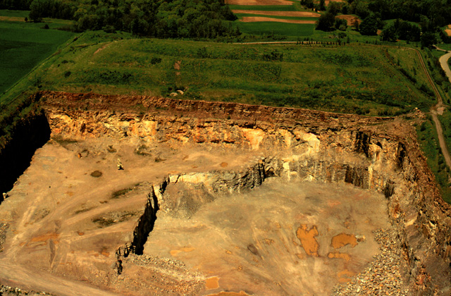
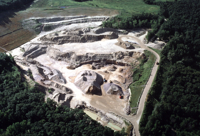
438-09: Pink Lady Quarry north of Rock Springs, WI. Vertical Baraboo quartzite is being quarried here for railroad ballast. View to the northeast. Note the jagged valley wall of Ableman Gorge in the foreground. Quarrying operations had created a dividing rock wall that was, by State Law, too narrow for its height; the top of the divide was lowered. (30Aug99)
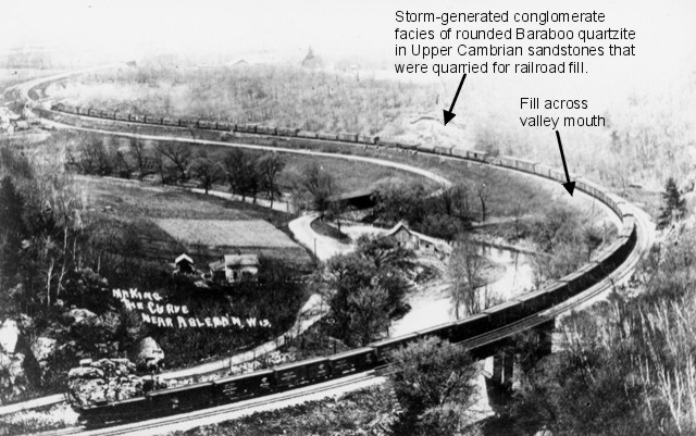
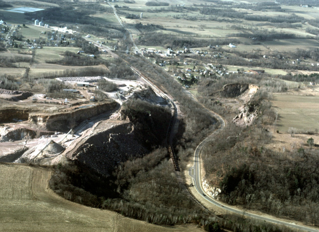
Ablemanv.jpg: "Making the Curve near Ableman, Wis." is an interesting picture postcard that was taken in the Upper Narrows in the early 1900's. Ableman was the former name of Rock Springs, WI. The picture is from the collection of Fred Galley of Portage, WI, who graciously granted me permission to use it. The photo fits with a collection of air photos because its original camera position is now a number of feet in the air owing to the lowering of the valley wall between the gorge and the adjacent Pink Lady Quarry (see comments with photo 438-09). The photo is undated, but it was probably taken during the first decade of the 20th Century. The second track was completed just after 1900, and the quarries that provided roadway fill--and the fill itself--are fresh and clearly shown on the photo. (The conglomerate was transported off-shore when Cambrian seas beat against the exposed quartzite cliffs.) The covered bridge, by which the road crosses the Baraboo River, was replaced in 1923 (Reedsburg Times, July 13, 1923). The large quartzite outcrop between the caboose and the highway (lower left corner) immediately caught my attention. Does it include Van Hise Rock? The railroad reverted to a single track in 1954, but the bridge foundation was not altered. In August 2000 I used a tape to measure the 186-foot distance between the stone foundations of the railroad bridge. The distance from the south foundation to Van Hise Rock is 309 feet. There are about four and one-third box cars on the bridge (each car averages 43 ft), and there are five cars between the bridge and the south end of the outcrop by the caboose (215 feet). Van Hise Rock must lie off the left end of the photo. See photo 443-10vc for the reconstructed position of this quartzite mass that was almost 60 feet long and 35 feet tall. A plaque was affixed to Van Hise Rock in 1923; perhaps that was the only way to save it from the same fate as the block on this postcard. My thanks to Donna Lange, Robert Dott, and William Cronon for information used in this caption.
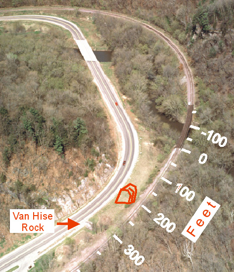
443-10: Ableman Gorge to the north of Rock Springs, WI. View to the north. The arrow points to Van Hise Rock; the red schematic structure indicates the quartzite outcrop shown on Ablemanv.jpg. Distance is measured from the south foundation stonework of the railroad bridge over the Baraboo River and the scale is corrected for perspective. (28Apr01)
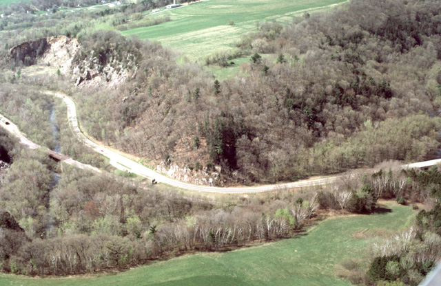
443-09: Ableman Gorge or the Upper Narrows just north of Rock Springs, WI. View to the SSW. Van Hise Rock is on the river side of WI Hy 136 just left of the center of the view. Abandoned quarries in the distance expose vertical Baraboo quartzite. (28Apr01)
434-13: Ableman Gorge just north of Rock Springs, WI. View to the northwest. Just past the cars there is a gathering for the Van Hise Rock National Historic Landmark Dedication. Van Hise Rock itself is to the right of WI Hy 136 just before it bends sharply to the left. See also photo 434-15. (9May99)
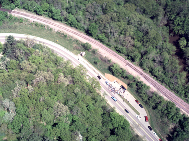
434-15: Van Hise Rock National Historic Landmark Dedication in Ableman Gorge (Upper Narrows) north of Rock Springs, WI. View to the northeast. Van Hise Rock is to the right of the gathering where the highway and the railroad are closest. See also photo 434-13. (9May99)
434-18: Gorge of Upper Narrows Creek of the Baraboo Syncline 2 miles west of Rock Springs, WI. View to the northwest; Reedsburg, WI is in the distance at the right. Remnants of the Upper Cambrian sandstone that once filled this valley can still be found; hence the original valley cut in the Baraboo quartzite predates that time. (9May99)
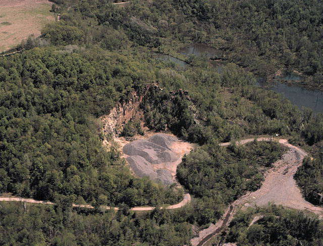
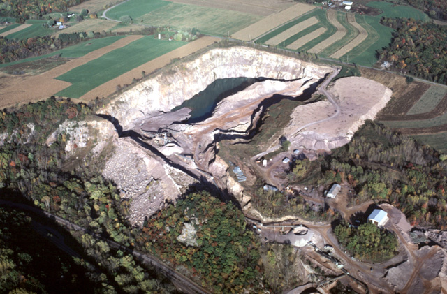
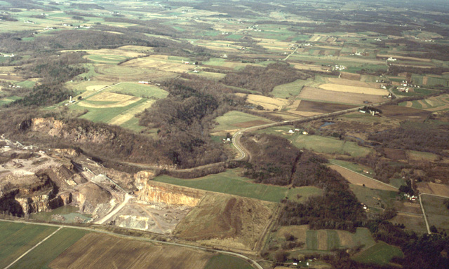
434-10: La Rue Quarry, 1 mile south of La Rue, WI. View to the southeast. The quarry is in the Baraboo Quartzite (Precambrian) on the south limb of the Baraboo Syncline. Note piles of broken quartzite that are awaiting shipment. (9May99)
152-17: La Rue Quarry, 1 mile south of La Rue, WI. View to the east. This is one of the few quarries in the Baraboo area where the marine Cambrian sandstone can be seen to overlap directly on to the intensely eroded Precambrian Baraboo quartzite. The light yellow sand overlies the purple quartzite at the left side of the quarry and rises to the right. The light-colored vertical cliff at the right of center is quartzite all the way to the surface; its tan color is caused by stain on a joint surface. (3Aug66)
439-02: Ground view of La Rue Quarry, one mile south of La Rue, WI. View to the east. The quarry is in the Baraboo Quartzite (Precambrian) on the south limb of the Baraboo Syncline. At the lower right are piles of broken quartzite awaiting shipment. The horizontal light-colored friable Cambrian sandstones in the left to middle view unconformably overlie the northward-dipping Baraboo quartzite. At many localities around the Baraboo syncline, Cambrian storms carried coarse quartzite conglomerate off-shore forming tongues of conglomerate in the sandstone. But at this sheltered position on the inside of the quartzite "atoll" (see initial map Barabovc.jpg), only a few angular blocks mark the unconformity. (2Oct99)
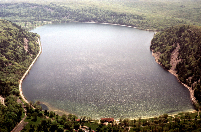
152-21: Devils Lake cliffs at Devils Lake State Park, 3 miles south of Baraboo, WI. View is to the northwest. The Precambrian quartzite, on the south limb of the Baraboo Syncline, dips to the north. The quartzite valley in which Devils Lake is located was blocked by glacial moraines during the Quaternary; the northern blockage can be seen at the upper right. (3Aug66)
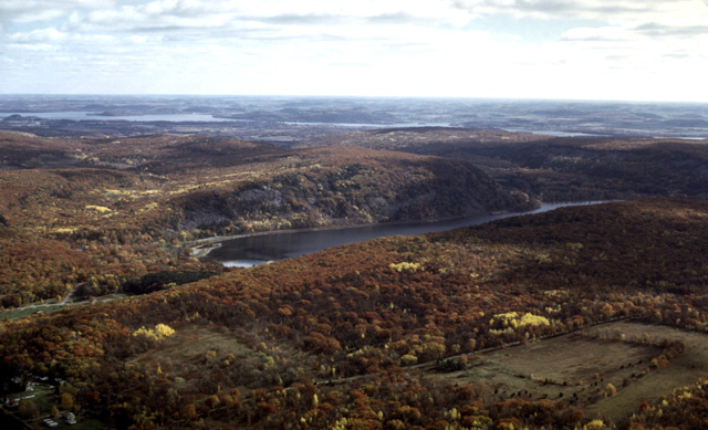
276-36: Precambrian river valley across the south limb of the Baraboo Syncline at Devils Lake State Park, WI. View to the southeast with the Wisconsin River and hills of Paleozoic strata in the distance. Fall vegetation of mixed hardwoods with some pines. (23Oct78)
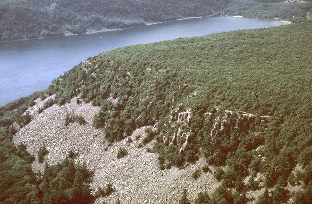
431-14: Devils Lake gorge, 7 miles southeast of Baraboo, WI. View looking west. The tree-covered mass that blocks the valley just this side of the lake is the end moraine of the Green Bay lobe. The moraine can be traced over the uplands on both sides of the gorge. Devils Nose is on the left; the line along its base is the route by which the Chicago and Northwestern Railroad crosses the South Range of the Baraboo Syncline. (30Jun98)
431-21: Devils Lake gorge, 3 miles south of Baraboo, WI. View looking south. This "L"-shaped river gorge across the Precambrian quartzite of the South Range of the Baraboo Syncline was cut previous to Upper Cambrian time when it was filled by marine sandstone. The whole area was deeply buried by Paleozoic marine sediments. When these were eroded away, streams that encountered the buried quartzite ridge migrated laterally and excavated the earlier quartzite gorge. When Pleistocene glaciers reached the eastern portion of the Baraboo Range, the terminal moraine of the Green Bay lobe blocked off the gorge and Devils Lake was formed. The tree-covered ridge this side of the lake is the northern moraine dam; the southern blockage is just around the left-turn bend at the other side of the lake. (30Jun98)
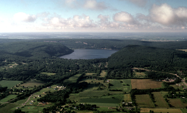
434-09 Devils Lake in Devils Lake State Park, 3 miles south of Baraboo, WI. View looking south. The Chicago and Northwestern Railroad skirts the lake at the left. The lake formed in an ancient quartzite gorge that was blocked near each end by glacial moraines. (9May99)
444-24: Quarry in the Johnstown Moraine along Tower Road at the crest of the South Range of the Baraboo syncline 5 miles SE of Baraboo, WI. View to SW. Quarrying began in outwash sediments west of the moraine. A few years ago the underlying Baraboo quartzite was encountered (center of view), and it is being utilized as well. (11Jul01).
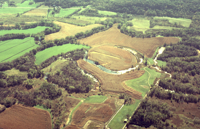
429-20: Cut-off meanders of the Baraboo River about 2 miles east of Baraboo, WI. View is toward the southeast. The river flows to the east (left) in a contorted tree-lined channel. The river has a low gradient which will probably diminish as glacial rebound continues. (16Oct97)
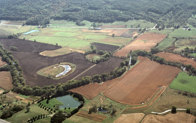
429-16: Baraboo River about 3 miles east of Baraboo, WI. River flows from right to left. View is toward the southeast. (16Oct97)
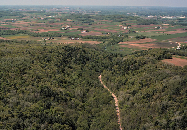
434-20: The Lower Narrows on the north limb of the Baraboo Syncline, 7 miles ENE of Baraboo, WI. View to the north. The tree-lined Baraboo River, which enters the Baraboo Syncline by Ableman Gorge, leaves the syncline through this cut. State Hy 33 also takes advantage of this route across the quartzite ridge. (9May99)
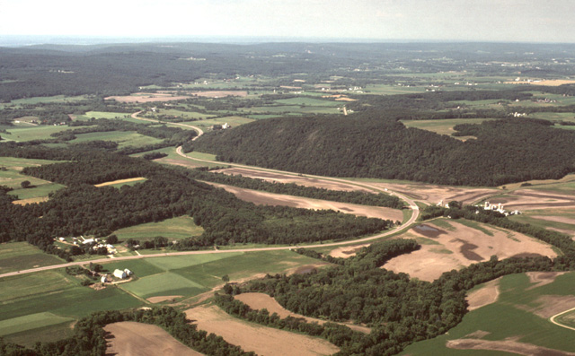
440-27: Lower Narrows of the Baraboo Syncline through which the Baraboo River and WI Hy 33 pass. View toward the southwest. (30Jun00)
Copyright © 2001 Louis J. Maher, Jr.