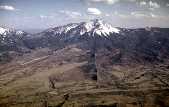
 West Spanish Peak near Walsenburg, Colo., is an igneous stock that is being exposed by erosion. Wall-like structures radiating from the peak are called dikes.
Reprinted from AOPA Pilot all rights reserved. Photos by Louis Maher and Charles Mansfield.
(Originally printed in Maher, L. J. Jr., 1968. Geology education by lightplane: The AOPA Pilot, v. 11, n. 1, p. 60-65.)
GEOLOGY EDUCATION BY LIGHTPLANE
University of Wisconsin professor brings the geological wonders of the West to his students with the aid of a Cessna 170B and color photography.
by LOUIS J. MAHER / AOPA 262920
“Charlie, what can you throw out to lighten us up?” Charlie inserted a new film magazine. “Nothing but the cameras.”
La Veta Pass over Colorado’s Sangre de Cristo Mountains still was 500 feet above us to the west. For the past five minutes the rate of climb needle had hovered at zero or just below. A Cessna 170B should be good for 14,000 or 15,000 feet, and here we were climbing at 80 m.p.h. at full throttle with the altimeter stuck at 8,800. It’s frustrating. I decided to get farther back away from the mountains and out of the air sinking along their lee slope.
Charlie Mansfield was aiming his camera at an igneous dike ridge along the flank of West Spanish Peak. “Hold the maps, I’m going to open the window....” If he said anything else it was lost in the roar as the window flipped up in the airstream to oscillate lazily near the wing. The rate of climb needle jumped momentarily to +1,000 as the cabin pressure changed; it settled back, but stopped before the needle reached zero.
West Spanish Peak near Walsenburg, Colo., is an igneous stock that is being exposed by erosion. Wall-like structures radiating from the peak are called dikes.Geology lends itself to visual presentation. I have always felt that a beginning student could learn a lot more if he could get out in the field to look at the rocks rather than just hearing about them in a classroom. But there just is not time for much of that sort of instruction at a large university. Television seemed to offer some interesting alternatives to the normal lecture course. You can show the class views through a microscope, or you can move from the classroom to the Grand Canyon and back without a break. The possibilities are almost limitless.
But a real problem arose back in 1965 while I was planning the outline of some 43 lectures. Many of the available photographs and films that I wanted to use were copyrighted. Although they could be shown free to normal classes, royalties were required once they were put on video tape. The project was going to cost enough as it was. In addition to television production expenses, a whole year of my salary would go into it, and we all know “how wealthy university professors are.”
The personal slide collection that I had assembled over the last dozen years was pretty good in some respects, but because it tended to represent my own special interests and experiences, several branches of geology were poorly represented. In addition, some of the slides had been taken with the camera tipped so that the long dimensions of the pictures were vertical. These would not fit the television screen, as its long dimension is horizontal.
I decided to solve my problems by getting a couple of cameras and spending three or four weeks out west filming my own material. It was not difficult to get together a list of places to visit because I had worked out there a number of summers. And in the long run it would be cheaper and quicker to get original films than to buy or rent duplicates from others.
Then a happy thought occurred to me. Why not get some of the pictures from the air?
Like many of you, I started learning to fly when I was in high school. Most of the profits from a paper route went into lessons in a Piper Cub when I was 15. Before I was old enough to solo, I got interested in cars and girls. The logbook had gathered dust until 1964 when I decided to get the private pilot rating. By the time the TV project started I had about 90 hours in the book. Four or five of these were logged scouting terrain during field work in Wyoming.
It happened that the geophysics section of our geology department had a Cessna 170B that had been purchased for aeromagnetic research. They still stuffed the rear of it full of recording gear from time to time, but when I heard about it, old N2398D was standing empty at one of our local airports. It had been modified to include a full set of instruments and radios, and it handled like a big friendly 140, in which I had most of my time. Best of all, it was available by the hour at cost, and the University agreed to absorb 100 hours of flight time for the project.
With that, I figured I could take several short trips around the Midwest as well as a longer flight out to the Rockies. By using the University’s plane and flying it myself, these photo trips would add up to a tiny fraction of costs by a commercial firm.
One of our graduate students, Charles Mansfield, said he would like to go along as photographer. We used the chart service of AOPA to get most of the sectionals of the West and then laid out a tentative route. We planned to take the trip during our spring vacation, which extended from April 8 through 17. Although that was a little early to expect favorable weather, cool temperatures would help 98D’s climb. Besides, it was the only time we could mutually schedule that many days away from the campus.
On a March afternoon, Charlie and I took the plane out to get some experience with the cameras. We had put a special latch on the right cabin window so it could be opened wide. Charlie rode in the rear seat where he could shoot to either side of the wing strut. After the film was developed we looked at the results and set up a number of rules of thumb to use on the later trips.
Our 35mm still camera offered no problems. It had a reflex view finder and built-in light meter. The lens could be focused at infinity and left alone. I had better comment on the settings for shutter speed that we used with Kodachrome II film.
If the air is smooth and the plane is high, there is little apparent motion, and you can get sharp pictures with a relatively slow shutter speed, say 1/60 or 1/125 second. But when the air is rough or when the plane is low, there is a lot of apparent movement and the shutter speed should be 1/250 second or shorter. Personally, I favor 1/125 or 1/250 second speeds in all but extreme cases. With these slower speeds, the aperture can be set at high F numbers, giving better depth of field. Then if part of the strut or wing gets in the picture, it looks sharp and adds interest to the photo rather than becoming a blurry distraction.
If the still camera was easy to use, the movie camera was another matter. I had settled on a 16mm Bolex reflex camera with hand grip and zoom lens as the most versatile camera I could get for the various projects I had in mind. The Bolex is made like a fine watch, but with the zoom lens it is heavy and rather bulky to use while hanging out of the plane window. That was Charlie’s problem, but he got pretty good with it. Before long he could reload a 100-foot roll of film in just under a minute. That takes some doing in a moving plane.
For most sequences, the lens was set at infinity and the zoom lens was adjusted to its shortest focal length of 17mm. In this wide-angle position we could get a good view forward and avoid the strut. We used the longer focal length (telephoto) portions of the zoom lens sparingly because it was hard to hold the plane and camera still enough to avoid “jumpy” pictures.
One of the critical problems with movies is the choice of the correct film speed. The normal projector speed used on television has to be 24 frames per second for electronic reasons. But the camera should film at that speed only when the plane is high and in smooth air. Most of the time we shot at 32 or 48 f.p.s., and when we were very low we went to 64 f.p.s.
There are three reasons for photographing at higher speeds. First, when the film is projected later at 24 f.p.s. you get a nice slow-motion effect that gives the viewer time to recognize what you are showing him. Second, any jerks or bounces are less noticeable, and you have enough film to edit out the worst without losing the whole sequence. Third, film speed is directly related to shutter speed. The faster the film speed, the shorter is the exposure time for each frame, so there is less chance of blurring the image on each frame. Our light meter was calibrated to read F numbers directly from the film speed setting. There were a number of other controls that Charlie had to watch on his camera, and he taped a check list on the back of it to remember them.
April 8, Friday, came almost before we were ready. I had spent the previous evening inking a tentative route on our charts. Early Friday morning I got a favorable weather report, said goodbye to my wife, Jane, and our two small sons, and met Charlie at the airport. We checked the plane, loaded our flight bags and film, tied the foam plastic-lined case for the Bolex next to Charlie in the rear seat, and strapped the briefcase of sectionals in the right front seat. We were off on schedule.
Twenty-five minutes later we landed at Lone Rock, Wis., after running into snow flurries. The staff at Lone Rock FSS suggested we file for flight following service to Mankato, Minn. FVFR has now been discontinued, but it was nice to know then that someone was watching our progress and passing weather information to us. The weather was VFR, but not good VFR.
So the trip started, as it were, under a cloud! The sky cleared completely by the time we got to South Dakota, and we tied down for the night at Pierre.
It frosted during the night, and the engine was a brute to start. But we were able to make the Badlands early Saturday while the sun was still low enough to provide excellent shadow detail.
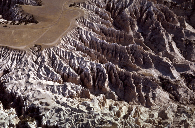 Sreams eroding headward into Table Mountain, Badlands National Monument, S.D., have left some unusual geological formations.
After the Badlands we headed for Rapid City to refuel. It was a difficult airport to locate. We knew just where to look by checking landmarks on the map, but the grass at that time in the spring matched the color of the runways and hangar roofs. I noticed an unpleasant but familiar smell on final approach and turned to find Charlie clutching a “sick sack.”
On the ground, he reported that the last roll of movie film had been run through the camera with the variable shutter in the closed position; it was never exposed. After rewinding it by hand, he “borrowed” some airsick tablets from one of the airlines on the field, and we left for the Black Hills. Although we had missed a good movie sequence in the Badlands, it did not seem advisable to return. Besides, I felt this early mistake would insure it would not happen again. Charlie underlined the variable shutter on his check list.
The geologic structure of the northern Black Hills around Deadwood was accentuated by a light cover of snow. After an hour we headed for the Big Horn Mountains of Wyoming by way of Devil’s Tower. When we landed at Sheridan, the FSS notified us that a front was moving in from the west and was due sometime the following morning. It was moving slowly, and they did not know how long it would take to clear after it passed. I had planned to try to reach western Wyoming early in the trip because if the weather were bad, we would fly south and hope to return when conditions improved. So we got a motel and spent the evening working with the charts.
Early on Easter Sunday we were flying south toward Colorado in good weather. As I was not enthusiastic about refueling and taking off at Laramie Airport’s 7,273-foot elevation, we hoped to get all the way across the Laramie Range to Boulder. Winds at 9,500 were favorable, and we dined on hamburgers before pushing south along the Front Range to Pueblo.
Although Charlie had been snapping pictures all along the front Range, I wanted especially to photograph the superb igneous dikes that radiate from the Spanish peaks southwest of Walsenburg, Colo. Late in the afternoon we were to meet La Veta Pass, our first relatively high mountain barrier.
As I mentioned earlier, it took some time that warm afternoon to get high enough to attempt the pass. Finally we were able to clear the Sangre de Cristos with 2,000 feet to spare. Entering the San Luis Valley, we turned north to the Great Sand Dunes National Monument where we photographed the dunes in good evening light before landing at Alamosa.
The trip Monday took us to a huge old volcano near Santa Fe and across the San Juan basin to Farmington, N.M. Turbulence was developing early so we planned to spend the afternoon on the ground. Farmington Airport is situated on an old river terrace now 200 feet above the city. Its runways form a flattened “X” pattern. The tower cleared us to land on Runway 25, and I was having some trouble watching for traffic and getting my directions oriented.
I was getting nowhere trying mentally to subtract 180° from 250° to establish the heading for the downwind leg when I hit on a simple method that helped me. I will mention it in case anyone else has problems figuring reciprocal directions quickly either at airports or omni stations. If you can subtract 200° from the given compass direction, do so, and add 20° to the result (250 - 200 = 50; 50 + 20 = 70). If you cannot subtract 200° from the course, add 200° and subtract 20° from the result.
We left at first light Tuesday. Although the land below us was still half dark, the snow-covered San Juan Mountains to the north were gleaming brilliantly. I had spent several summers working on a thesis in the San Juans, and I wanted to get photos in the high country while the air was still smooth.
Niner-eight Delta was pushing 13,000 when we finished. Charlie spent the next half hour trying to thaw out his hands and face while at the same time shooting the cliffs of Mesa Verde and the old volcanic neck Shiprock. We headed westward over the 9,000-foot Chuska Mountains toward the Hopi Buttes. After photographing these lava remnants we passed over Meteor Crater and gassed up at Flagstaff. On a warm, still day at the runway’s 7,000-foot elevation, the Cessna’s ground speed at landing is 10 to 15 m.p.h. faster than at the lower elevations I was used to. It is quite noticeable on the final flare-out in a plane with conventional gear.
The afternoon’s flight was a geologist’s dream. The rocks of the Canyon Country were laid out below us like pages of a book. I wish more people would appreciate the geologic features over which they fly. But with today’s navigation aids, I suspect the trend is toward watching omni needles during ever higher flights rather than savoring the subtleties of the earth below.
After Flagstaff’s volcanoes we got to the Grand Canyon to find rain showers coming in from the west, so we headed up the river to Glen Canyon Dam and Rainbow Bridge. Then we worked eastward along the San Juan River photographing its “goosenecks” and Monument Valley to land an hour before sunset at Cortez. Colo.
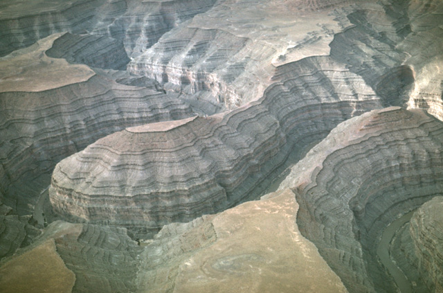 The Goosenecks of the San Juan River, west of Mexican Hat, Ut. Meandering pattern of the stream has been cut deeply through layers of sedimentary rocks. The river maintained its course even though the land was pushed upward.
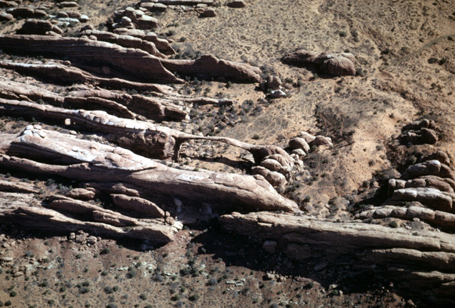 Vertical joints have broken horizontal rock layers into a series of slabs in this part of Utah's Arches National Monument. Landscape Arch, near center of photo, is an erosional remnant that has a span of 290 feet and a height of 120 feet.
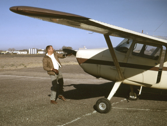 The author and N2398D during preflight check at Burley, Ida.
Thursday was a long day. Craters of the Moon National Monument are much more spectacular from the air than from the ground. The barren lava flows and cinder cones stretch for miles on the north side of the Snake River. The lava is so porous that surface streams are rare.
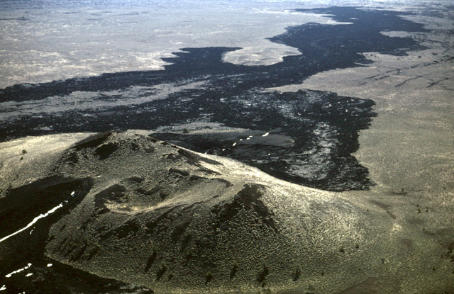 This double volcanic cone was built over a fracture in the ground at Craters of the Moon National Monument in Idaho. The break, accentuated by snowdrifts, runs from lower left to upper right. Darker lava flows fill the valley in background.
 We refueled at Idaho Falls and got a favorable weather report. Skirting to the west of the Tetons, we got up to the Yellowstone Plateau and made the “Grand Loop” from Old Faithful to Mammoth and back south by the Canyon to Yellowstone Lake. I have taken students to that park on several occasions, but I have never appreciated it more than on that cloudless April day. What a country! Charlie kept himself busy out the window; he nearly froze both of us before we reached the Tetons and Jackson Hole Airport.
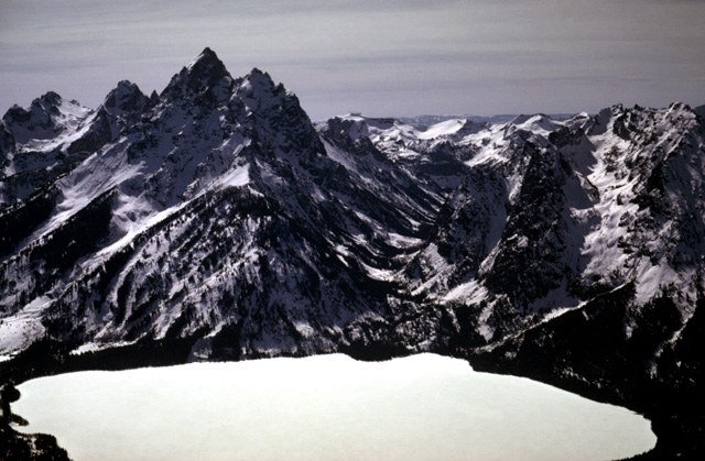 Wyoming's Grand Teton rises almost 7,000 feet above snow-covered Jenny Lake. U-shaped valley of Cascade Creek at right of Grand Teton once was occupied by a glacier.
The route then followed along the southern flank of the Wind River Range where a number of old glacial moraines are displayed especially well. By late afternoon we were able to cut across the southeast end of the range to reach Lander.
Our motel owner kindly let us use his car to get to the airport Friday morning, saying,“Just leave it in the lot. I’ll have one of the boys pick it up later.” We cut across the Owl Creek Mountains and flew along the Big Horn River to Greybull, Wyo. North from there to Lovell there is a wonderful little area of folds around a ridge called Sheep Mountain. The ground is almost completely without vegetation, and the bending rock layers make beautifully colored patterns that clearly show anticlines, synclines, and faults. Charlie got a good series of shots from high altitude, and then we dropped down to get close-ups. The ground motion shown in low altitude movies adds a three-dimensional aspect to the landscape that is very effective. As far as I am concerned, the hour we spent at Sheep Mountain more than paid for my private license.
After flying to Cody to shoot some features near there, we turned northeastward to follow the Big Horn River Canyon across the Big Horn Mountains. We stopped at Sheridan for the second time in seven days to refuel and eat, and I decided we would drop by the Badlands to get the movies we had missed on the first attempt. By now the Black Hills looked pretty small so we flew directly over them to reach the Badlands by mid afternoon.
The air, strangely enough, was perfectly smooth and Charlie’s low-level sequences more than atoned for his earlier mistake. We reached Valentine, Neb., by dusk after an interesting trip over the Sand Hills region.
Saturday we flew eastward to Wisconsin. There was no doubt that we had returned to the Midwest, for the visibility closed down to four miles and we bounced along through April showers.
A week later several feet of snow fell on the western part of Wyoming. Talk about luck! We had gotten nine days of picture-taking weather in early spring and averaged eight hours of flying time each day. Furthermore, the trip had been made even more pleasant as everyone we met or talked to by radio had been friendly and helpful.
Later in the season, we were able to take several other short trips in the Midwest. The flights produced hundreds of color slides and several thousand feet of movie film. This photographic collection considerably enriched my television geology course. I hope the students learned geology from it; I know I did!
In his article, author Louis J. Maher deals briefly with his flying background. The 34-year-old associate professor at the University of Wisconsin has been an AOPA member since 1964 and reports that he flies whenever the opportunity presents itself. Availability of a Cessna 170B owned by the school gave him the chance to make the trip described in this article, which he says proved to be as educational to him as he hopes its results have been to his students.