Frequently asked questions
MORVEL is an estimate of geologically recent global plate motions and their uncertainties. MORVEL describes the motion of 97% of Earth's surface, with the caveat that it provides less accurate estimates of crustal movements in some of the wide deforming zones that define some plate boundaries. For 20 of the 25 plates that comprise MORVEL, their relative motions are estimated using geological data that average plate motions over hundreds of thousands to millions of years (also see below). For five smaller plates with few or no reliable geological data to estimate their motions, GPS data were used to link their motions to other plates. The part of MORVEL that is determined from geological data is isolated mathematically from the part determined from GPS data in order to avoid an exchange of kinematic information between these data types, which average plate motions over vastly different time scales. Mathematically, MORVEL consists of 24 angular velocities that describe the motions of 24 plates relative to an arbitrarily fixed 25th plate, plus the uncertainties in those 24 angular velocities. The relative movements between all possible paired combinations of those 25 plates are constructed from those 24 angular velocities.
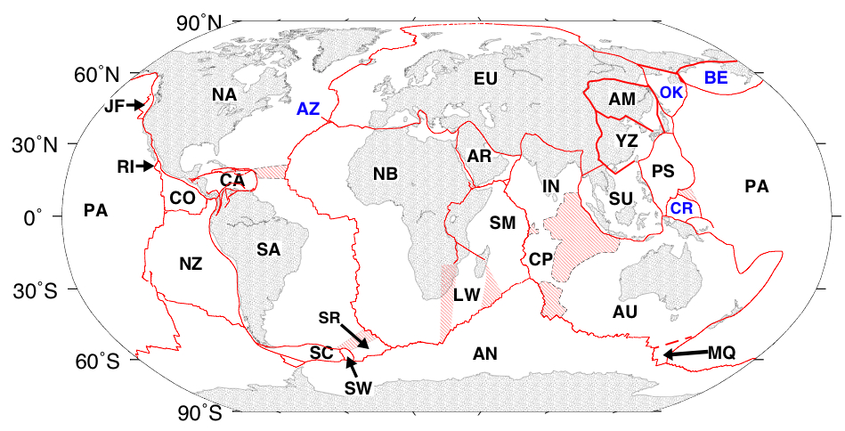
Figure 1. The boundaries (red) that define the 25 plates in MORVEL. Plates identified with blue lettering are not included due to a lack of useful marine geophysical and geodetic measurements for estimating their motions.
What does the "MORVEL" acronymn represent ?
MORVEL is shortened from Mid-Ocean Ridge VELocity and is so named because more than three-fourths of the MORVEL data come from the mid-ocean ridges. Despite its name, MORVEL describes the motions of the tectonic plates, not the mid-ocean ridges that separate many of the plates.
To what time period does MORVEL apply?
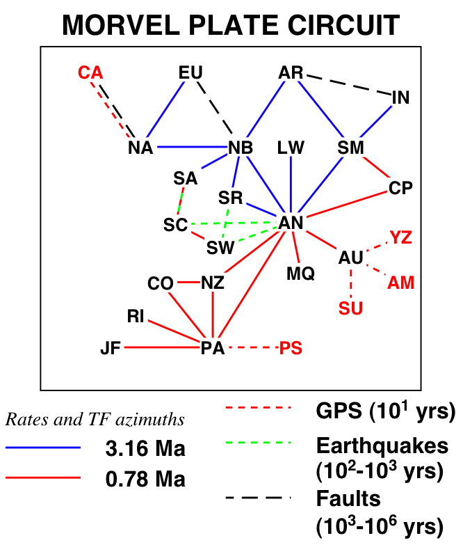
MORVEL gives velocities averaged over no longer than the past 3.16 million years; however the time period that applies for a given plate pair depends on the type of data that were used to estimate the motion for that plate pair. The figure at the right summarizes information about the time intervals over which data from the MORVEL plate boundaries average motion across those boundaries. For some rapidly moving plates, the mid-ocean ridge seafloor spreading record is clear enough so that seafloor spreading rates can be determined for the past 780,000 years. The motions of plates that are connected by those spreading centers can therefore be determined for the past 780,000 years. For some slowly moving plates, the seafloor spreading record is more difficult to read. Seafloor spreading rates and thus plate motion across those boundaries are averaged over the past 3.16 million years. Five plates (red labels in the figure) lack any seafloor spreading record along their boundaries. Their motions are averaged over the past 10 years from Global Positioning System geodetic measurements.
MORVEL is primarily (but not purely) a geological estimate and can be used as a basis of comparison to purely geodetic plate motion estimates for most plates.
What is the basis for the configuration of tectonic plates used for MORVEL ?
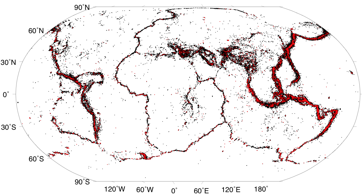
The configuration of tectonic plates, otherwise known as the global plate geometry, is determined in part from the distribution of shallow earthquakes from 1963 to mid-2008 (shown at the right) and in part from Earth's surface morphology. Earthquakes clearly identify areas of active faulting, where relative movement between different tectonic plates occurs along faults that separate them.
What kinds of observations are used to determine the MORVEL estimate of plate motions ?
Four kinds of observations provide reliable, unambiguous local estimates of plate movement that can be combined to estimate an individual plate's angular velocity.
(1) Rates of seafloor spreading are estimated from seafloor spreading magnetic lineations created along the mid-ocean ridges. These are the primary type of data used in MORVEL and are often accurate to within a few percent. Rates in MORVEL are averaged over 780,000 years (the width of the central magnetic anomaly) or the past 3.16 million years (the midpoint of magnetic anomaly sequence 2A).
(2) Directions of oceanic transform faults are locally parallel to the direction of relative plate movement and when surveyed with modern swath-mapping sonar can be used to determine the recent direction of plate movement to the nearest one degree. These are the second most important type of data in MORVEL. Individual fault strands remain active in transform fault valleys from thousands of years to millions of years and thus provide estimates of plate slip directions over a time scale shorter than most seafloor spreading rates, but much longer than earthquakes or geodetic measurements.
(3) Global Positioning System (geodetic) measurements at stations within plate interiors track the motion of a single tectonic plate at a single site over periods of years to decades and can be used to find both the rate and direction of plate motion at that site. Measurements are continuous if an instrument is located permanently at a site. Some sites are however occupied by a GPS instrument for just a few days per year or even less frequently. GPS site velocities are used as infrequently as possible in MORVEL in order to minimize the effect of these short-term measurements on the resulting suite of plate angular velocities.
(4) Horizontal slip directions during earthquakes are also usually parallel to the local direction of relative plate movement along plate boundaries where all plate movement occurs locally along a single fault. Since earthquakes typically rupture faults every few decades to a millenium or longer (thousands of years), earthquake slip directions describe plate movement over short periods relative to geologic time scales. In this respect, earthquake slip directions average plate motions over time scales comparable to those for geodetic measurements. Earthquake slip directions are used as little as possible for MORVEL in order to minimize the effect of these short-term measurements of plate movement on the long-term MORVEL angular velocity estimates.
Further information about some of the above data can be found in the data links in the left-hand column.
C. DeMets, D. Argus, & R. Gordon