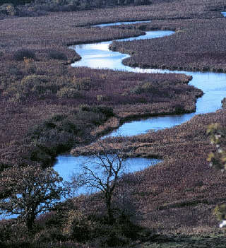
Pheasant Branch Marsh, just below the springs

A Report From The North Fork Pheasant Branch Watershed Committee
Information and recommendations for:
March 1999
Table of Contents
Coming Together For The Future
Birth of the North Fork Pheasant Branch Watershed Committee
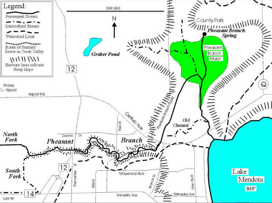
Description and Maps of Pheasant Branch and its Watershed
Ecological, Social, Economic, and Legal/Regulatory Problems and Challenges in the Watershed
North Fork Recommendations and Implementation Strategies
Appendix 1: A Glossary of Scientific Terms
Appendix 2: Description of Committee Process
Appendix 3: The Early History and Maps of the Pheasant Branch Watershed
Appendix 4: Land Engineering as a Water Management Technique
Appendix 5: Potential Funding Sources for Implementing Recommendations
Appendix 6: List of Committee Members
Appendix 7: Map showing Probable Substratum Permeability in the North Fork Pheasant Branch Watershed 29 (Large format map Not Shown on Web Site.)
Appendix 8: Map showing Hydric Soils and Open Space Corridors in the North Fork Pheasant Branch Watershed 30 (Large format map Not Shown on Web Site.)
Appendix 9a and 9b: Maps showing Prime Agricultural Land in the North Fork Pheasant Branch Watershed 31 - 32 (Large format map Not Shown on Web Site.)
The Pheasant Branch Watershed Committee acknowledges help from many individuals and organizations:
Darin Harris and Tom Mickelson, who facilitated our meetings.
A Great Lakes Aquatic Habitat Grant to the Friends of Pheasant Branch, Inc., which funded the committee's meeting and office supplies for 1998.
Middleton Community Bank, The Bruce Company, City of Middleton and Middleton Public Library, which donated space for committee meetings.
Janet Pulvermacher of Printing Services Management, Inc. in Middleton, who donated her services to design this publication.
Robert Queen, Wisconsin Department of Natural Resources, who provided the photographs for this publication.
Louis J. Maher, Jr., U.W.-Madison Department of Geology and Geophysics, who prepared the maps on pages 5, 7, 22 and 23.
Michelle Richardson, Dane County Land Conservation, who prepared the maps for Appendices 7, 8, 9a and 9b, and many large maps used by committee members during our meetings.
Dane County Regional Planning, which donated the printing services for this publication.
Copies of this report are available from Dane County Regional Planning Commission, 217 S. Hamilton Street, Suite 403, Madison, WI 53703 (608) 266-4137 or e-mail: dcrpcadm@execpc.com. This report can also be accessed on the following Internet Web site:
http:/www.geology.wisc.edu/~maher/pheasant_branch.html
Coming Together For The Future
Land use planning issues often polarize community groups, pitting farmers, developers, businesses, local units of government, taxpayers, enforcement agencies and environmentalists against one another to the point where civil communication seems impossible. Such conflicts usually result in battles where one side wins and others lose. This report describes a decision-making process in which many of these interest groups worked together to develop a land use plan where almost everyone won.
The fifty people who participated in this process are proud of their accomplishment and eager to share their results with others. Although their disparate interests are the fuel on which conflict thrives, these individuals committed themselves to a series of meetings. Over the course of several months, they developed respect for other views, gained new perspectives on old problems and, to their credit, became friends who wanted to share a common vision.
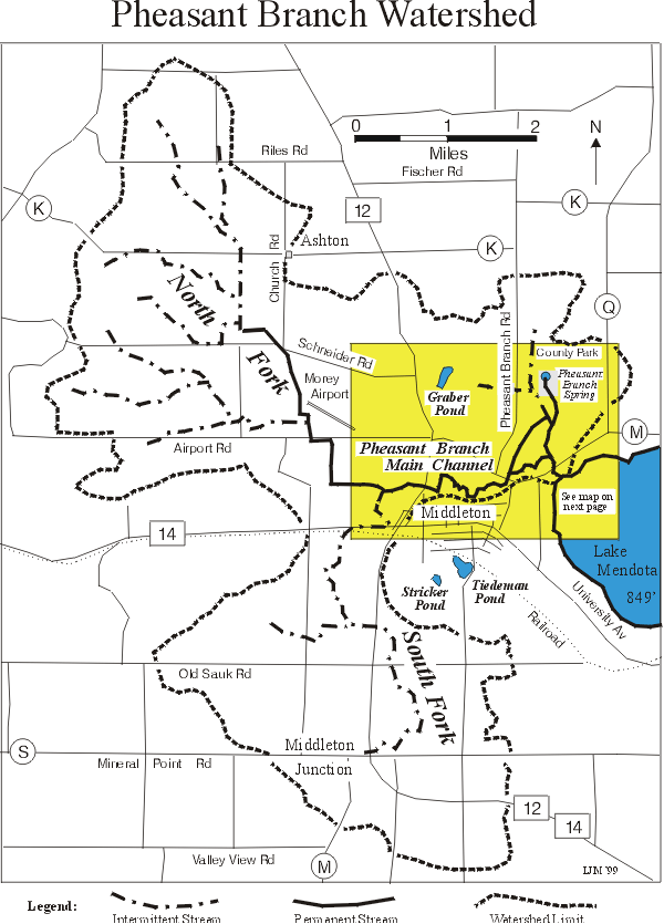
The focus of their efforts is the Pheasant Branch Watershed, a 23-square- mile area which drains into Lake Mendota. Prior to settlement, precipitation falling on the North and South Forks of this watershed drained into a large wetland that formed on what was once Glacial Lake Middleton. This area is now a flood plain along Airport Road in the Town and City of Middleton, Wisconsin.
Early settlers drained the wetland depression and channelized Pheasant Branch in the 1800s in order to harvest peat and farm the old lake bed. These activities greatly diminished the flood plain's ability to stabilize downstream flows, protect water quality and recharge groundwater.* Modern development in the flood plain and greater demand for municipal water threatens further to reduce groundwater supplies and increase streambank erosion.
[* Scientific terms used in this report are defined in Appendix 1: A Glossary of Scientific Terms]
What happens in the watershed today will have a significant impact on the volume of groundwater flowing from the Pheasant Branch springs, the ecological health of Pheasant Branch Marsh and the quality of water in our wells and Lake Mendota.
Birth of the North Fork Pheasant Branch Watershed Committee
The Bruce Company tried for more than five years to develop a 160-acre parcel it owns along Airport Road in the City of Middleton, Wisconsin, into a commercial business park. Although the city's master plan targeted this area for development, the company encountered many problems along the way.
The Friends of Pheasant Branch (Friends) had delayed construction of a sewer line that would allow a feeder to serve the company's site. The area lay in a flood plain that was subject to a high degree of engineering and ecological scrutiny. And local residents were very concerned about the impact of development on the creek, Pheasant Branch Marsh and Lake Mendota. The situation had potential for drawings scientists, local developers, public agencies and environmentalists into a long, heated battle.
The turning point came in the spring of 1998 when The Bruce Company plans were undergoing review by the city and the Department of Natural Resources (DNR). When the Friends expressed concerns about the narrow perspective of the City's and DNR's review process, The Bruce Company agreed to work with the Friends in organizing a committee that would examine their project and other potential developments within the broader flood plain context.
Some people were skeptical about developers and environmentalists working together. Others, responsible for reviewing development plans, feared the committee's work would interfere with their permitting processes. But many were intrigued by the possibility that potential adversaries, scientists and government officials might be able to reach a meaningful agreement.
Two DNR facilitators helped a core group organize the committee and their assistance remains vital to the committee's work. (See Appendix 2: Description of Committee Process) At organizational meetings, the committee developed goals and decided that any solutions they proposed would need to:
About fifty people participated in the committee's work. They included watershed property owners, citizens, developers and their engineers, other business people, Middleton City officials, and U.W. engineering and geology professors. Other members represented Dane County Regional Planning, Dane County Land Conservation, the DNR and U.S. Geological Survey (USGS). (See Appendix 6: List of Committee Members) Another forty people were kept informed through regular mailings.
Committee members recognized that land use activities have affected the watershed's natural resources in the past, and will continue to do so in the future. Adverse land use practices harm natural resources not only at the site, but downstream as well. For example, past development of the South Fork Watershed in the Cities of Madison and Middleton may have been well-intentioned, but lacked the benefit of state of the art erosion control and stormwater management practices. As a result, the City of Middleton has committed more then $4 million to correct problems that, in hindsight, might have been avoided with better planning and construction site practices. The environmental costs are incalculable. The South Fork channel has become a highly erodible drainage ditch and high volumes of stormwater threaten structures along the main channel. Moreover, thousands of tons of silt have degraded the ecological value of Pheasant Branch Marsh, clogged the mouth of the Pheasant Branch channel and greatly reduced water quality in Lake Mendota.
Committee members also recognized that properly planned development and ecologically sound land use activities have the potential to protect natural resources and prevent further degradation. During eight months of meetings, committee members heard about soil and water conditions in the North Fork Watershed from many scientists. They learned how it is possible to enhance infiltration and storm water retention on some parcels of land in the flood plain. However, other parcels with highly permeable soils are best left undeveloped because they have a natural capacity to recharge groundwater supplies and reduce sediment and stormwater runoff. Groundwater helps to maintain water levels in the North Fork and main channel of Pheasant Branch, and is the main source of water for the Pheasant Branch springs.
Working together, privately-funded and public agency experts defined a number of innovative construction site and stream restoration practices to enhance infiltration and stormwater retention on one parcel of land earmarked for development. DNR South Central Region personnel are now promoting the land engineering practices described in this report when they review other development proposals.
During their eight months of meeting, committee members learned to trust one another and became friends. As a result, their recommendations for local units of government, review agencies and developers reflect a consensus of broadly diverse interests. Now they are working together to secure funding for their plans and encourage groups they represent to support their proposals. The document summarizes their findings and recommendations, and provides an example for other groups who face similar land use challenges.
Description and Maps of Pheasant Branch * and its Watershed
[* The words "branch," "stream" and "creek" are synonymous and used interchangeably in this report.]
The Pheasant Branch Watershed drains into Lake Mendota. It covers approximately 23 square miles in an area that includes portions of the Towns of Middleton and Springfield and Cities of Madison and Middleton. (Please refer to the Pheasant Branch Watershed Map on Page 5) Until the mid-1800s, the Pheasant Branch Watershed above the elevation of Highway 12 drained into a large wetland flat that surrounds the present confluence of the North and South Forks of Pheasant Branch near Airport Road in Middleton.
Water stayed in the wetland most years, though it may have spilled westward into the Black Earth Creek Watershed during extremely wet conditions. Early settlers created the North Fork channel when they drained the wetlands in the 1800s and redirected water into a natural channel east of Highway 12. That channel, which has probably emptied into Lake Mendota for thousands of years, became the main Pheasant Branch channel. (See Appendix 3: The Early History of the Pheasant Branch Watershed)
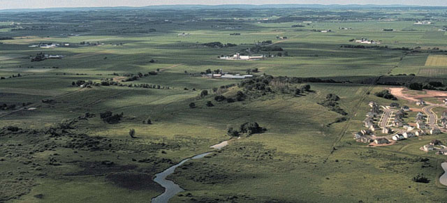
Present-day Pheasant Branch originates out of the glacial moraine in the Towns of Middleton and Springfield, and flows through the City of Middleton before entering Lake Mendota. The seven-mile long creek has four distinct parts, the South and North Forks upstream from Highway 12, and the upper and lower portions of the main channel. Each of these reaches has its own particular conditions and problems.
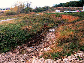
Land in the South Fork Watershed is almost fully developed. This area probably had no well-defined channel prior to European settlement. The present channel results from agricultural and urban development, and is little more than a stormwater drainage ditch, with no baseflow and minimal ecological value. During intense rains, the channel has flashy flows which carry high concentrations of suspended sediment from channel and construction site erosion downstream to Pheasant Branch Marsh and Lake Mendota. Given the degree of development, opportunities for retrofitting stormwater retention devices and restoring the stream are limited.
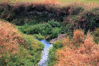
Land in the North Fork Watershed is mainly agricultural. Most of the North Fork channel consists of agricultural ditches constructed to drain extensive wetlands that once existed in the present flood plain. The channel has a small amount of baseflow, most of which occurs south of Schneider Road. Wetland destruction, sediments and nutrients from agricultural fields, and barnyard runoff have destabilized stream banks downstream, elevated water temperatures and destroyed fish habitats.
If the North Fork Watershed were developed without adequate storm water management, heavy rains would accelerate channel erosion, and loss of groundwater recharge could further reduce channel baseflows. Inadequate management of construction site erosion would result in delivery of large quantities of sediment to the Pheasant Branch Marsh, causing further destruction of wildlife habitats. Increased loads of phosphorous that are associated with sediment would also cause more turbidity and exacerbate summer algae blooms in Lake Mendota. Conversely, good planning before development occurs, and use of sound management practices now would greatly enhance ecological conditions in the North Fork. Such practices include innovative storm water and erosion control techniques, improved agricultural conservation methods designed to reduce sediment and nutrient discharge, and wetland restoration to increase baseflow and trap sediment. (See Appendix 4: Land Engineering as a Water Management Technique)
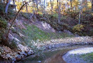
The Main Channel of Pheasant Branch runs through the City of Middleton from Highway 12 downstream to Lake Mendota. (See Main Channel Map on Page 7) Stormwater runoff is largely responsible for eroding the upper portion of this channel. Since human settlement, farming, urban development and ditching have accelerated runoff and inhibited water infiltration. The channel's flow, accelerated by a large elevation drop (about 90 feet in 2 miles), has widened and deepened the channel banks which are composed of sandy, non-cohesive soils. Opportunity for erosion is further enhanced by a forest canopy along the stream which inhibits groundcover growth, leaving bare soil exposed.
Efforts to decrease stormwater runoff would reduce erosion rates and the public and private costs of repairing erosion damage. Presently, erosion in the upper reach of the main channel valley threatens several structures. The City of Middleton recently contracted for repairs of slope failure that endangers a private residence. Erosion also threatens two bridges, an old sanitary sewer interceptor buried along the channel and a newly constructed sewer crossing. Since the late sixties, the city has spent about a half million dollars for main channel stabilization. These attempts to mitigate upstream problems include streambank reinforcement, and structures that reduce flow during peak periods but prevent upstream fish migration.
The lower portion of the main channel flows into Pheasant Branch Marsh where it receives an estimated 1840 gallons of water per minute from a spring complex to the north. The combined flow is then conveyed through the Pheasant Branch Marsh to Lake Mendota. Because the land in this area is very flat, the lake level controls water levels in the final section of the creek. This portion of the channel is ecologically important because it connects the lake to a spring-fed marsh. Until heavy silting occurred, fish and other aquatic species living in the lake used the lower channel for spawning and other functions. *
Sedimentation is a major problem in the Lower Branch. Some of the sediment carried by the creek is deposited in the marsh; the rest is conveyed to Lake Mendota. Turbid water prevents vegetative growth in the channel and severely limits wildlife habitat potential. Better erosion control and storm water management would greatly improve conditions in this reach.
[* For more information about fish habitats in the Pheasant Branch, contact Michael J. Sorge for a copy of his April 1996 report, "Lake Mendota Priority Watershed Surface Water Resource Appraisal Report," at Wisconsin Department of Natural Resources, 3911 Fish Hatchery Road, Fitchburg, WI 53711. Telephone: (608) 275-3247 or e-mail: sorgem.dnr.state.wi.us]
Ecological, Social, Economic and Legal/Regulatory Problems and Challenges in the Watershed
Nearly all the problems in the North Fork Pheasant Branch Watershed relate to municipal water use, sediment or stormwater runoff. Committee members viewed these problems from ecological, social, economic and legal/regulatory perspectives. The following summarizes their findings:
[* See "Dane County Regional Hydrologic Study: Evaluation of Alternative Management Strategies, June 1997," prepared by Staff to the Dane County Regional Planning Commission in cooperation with the Wisconsin Geological Survey and Natural History and United States Geological Survey. The City of Middleton helped to initiate and continues to sponsor this interagency effort. Copies of the study are available from Dane County Regional Planning, (608) 266-4137.
Additional information is forthcoming: "Hydrology of Dane County, Wisconsin" by Kenneth R. Bradbury, S.K. Simonson, James T. Krohelski and Ann K. Fritz is in press and will soon be available as a Wisconsin Geological Survey and Natural History bulletin. Call Ken Bradbury at (608) 263-7921. ]
Social Problems and Challenges
Economic Problems and Challenges
Legal/Regulatory Problems and Challenges
North Fork Recommendations and Implementation Strategies
The recommendations put forth in this report all relate directly or indirectly to two key issues:
In order to protect valuable soil and water resources in Pheasant Branch Watershed, the North Fork Committee recommends the following:
1. Reduce erosion throughout the watershed[* Lake Mendota Priority Watershed Project has established goals to reduce the delivery of sediment and chemicals into the watershed's lakes and streams by measurable levels. These materials include sediment from crop land, streambank and construction site erosion, and phosphorous (which is responsible for summertime algae blooms in the lake) from barnyards, construction sites and urban areas. The project also seeks to protect surface and groundwater quality by reducing applications of manure, chemical fertilizers and pesticides. ]
b. Give high priority to erosion control.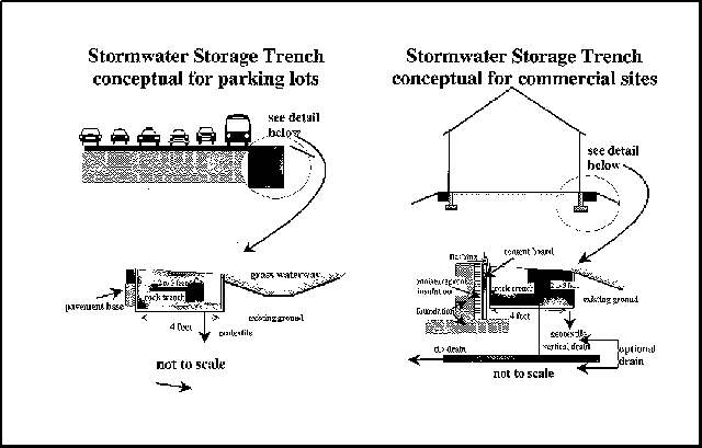
10. Apply North Fork committee process to other portions of the Pheasant Branch channel and watershed when land use conflicts arise.
This document represents a work in progress. It is simply the first step in a long, complex process to protect valuable resources in the Pheasant Branch Watershed. Even as it goes to press:
An ever-growing body of scientific knowledge clearly demonstrates the complexity of watershed issues, but also provides new techniques for mitigating past mistakes and preventing future problems. The North Fork Watershed Committee members will use these tools to enlist the cooperation of watershed citizens, property owners, developers and local units of governments.
The Committee will also seek funding to ensure that its recommendations are implemented before the North Fork is subjected to further development pressures. Timely action will ensure that:
Finally, North Fork Committee members will encourage their peers in the business and farming communities, government agencies and environmental organizations to use their committee process as a model for resolving land use conflicts. Widely diverse interest groups can reach consensus when they base their discussions on scientific information and understand one another's viewpoints.
Appendices
Appendix 1: A Glossary of Scientific Terms
Baseflow is that portion of the flow in a stream that originates from groundwater seepage.
Best Management Practices (BMP) are agricultural, forestry and development measures and engineering structures, such as retention ponds, that encourage the infiltration of surface water and the prevention of soil erosion.
Erodible soils are those soils that are likely to wash away when exposed to water runoff.
Erosion is the wearing away of soil or rock by wind, water, ice or gravity.
Grassed swales or waterways are shallow natural or constructed channels that filter barnyard runoff and urban stormwater pollutants through vegetation, and encourage infiltration. Urban grassed swales can be used in place of curb and gutter.
Groundwater is water contained in interconnected pores of rock or sediment layers.
Hydric soil is a soil that is saturated, ponded or flooded long enough during the growing season to develop oxygen-deficient conditions in its upper part. It is often called "muck" or "peat."
Infiltration is the process by which water from rainfall and snow melt flows down into and through the upper soil layers.
Land engineering involves the construction of swales, contoured terraces and other diversions such as retention ponds to reduce the velocity of stormwater runoff and increase infiltration.
Open space corridors are continuous open space systems are containing critical natural resource features, such as streams, lakes, shorelines, flood plains, wetlands, steep slopes and woodlands, that deserve the greatest degree of environmental protection. These systems are called urban environmental corridors when they preserve resources in urban service areas. Beyond municipal boundaries, open space corridors are identified as rural resource protection areas on town land use plans, and protected primarily through zoning. Isolated resource features lie outside open space corridors, but are protected because of their scientific, ecological or scenic importance.
Peak flow is the highest discharge flowing in a stream following a particular rain storm or snow melt.
Permeable soils are porous and allow water to pass through them.
Prime agricultural land is land having the best combination of physical and chemical characteristics, including soil quality, growing season, and moisture supply, needed to economically sustain high crop yields when managed according to acceptable farming methods.
Recharge is that portion of infiltrating water which reaches the water table.
Recharge area is an area in which infiltrating water readily replenishes ground water supplies.
Sediment is soil that has been eroded from land surfaces, often by water runoff, and deposited away from its original location.
Water table is the level at which soils and rock pores are saturated with groundwater.
Watershed is the entire area of land that drains into a given waterway, wetland or lake; also referred to as a drainage basin or catchment area.
Wetland is an area where water is at, near or above the land surface long enough to be capable of supporting aquatic or hydrophilic (water-adapted) vegetation, and soil types reflecting wet conditions.
Wildlife habitat is a set of specific environmental conditions that provide cover, shelter, food, breeding and rearing sites necessary to support the life cycle of a given wildlife species or group of species.
Appendix 2: Description of Committee Process *
[* Prepared by DNR Facilitators Darin Harris and Tom Mickelson. ]
As you might imagine, the subtle factors that allowed this committee to accomplish its goals are nearly impossible to put into words. The trust, communication, and teamwork that developed over the course of several months, however, resulted from a deliberate process used by the committee's facilitators and organizers. This short description highlights the need for a few key people to take leadership roles in the process. The following text summarizes the process.
Jan Coombs, from the Friends of Pheasant Branch in Middleton, originally recognized a potential problem in Pheasant Branch. Her initial interest, enthusiasm and effort cannot be emphasized enough.
A few things Jan did early in this process were key:
Another important factor for the committee's success was the use of two facilitators, Tom Mickelson and Darin Harris, who had worked previously with Jan. Such a large effort would have been extremely difficult to undertake without organizational and group development assistance. Tom and Darin helped in various ways:
The third important factor in the success of the committee's work was their effective use of small subgroups.
Countless other factors encouraged a high level of trust, involvement, and creativity in the committee:
Description of the Process Used By The North Fork Pheasant Branch Committee
1. Jan Coombs identifies a potential problem, she contacts local and state officials, but is not successful in catching their attention
2. Jan meets with DNR facilitators to discuss her concerns.
3. Jan and facilitators meet with DNR representatives for local region.
4. A series of small meetings and calls take place between various businesses, agencies, and environmental groups.
5. A few key "champions" from each group take an interest in addressing the problem.
6. Champions meet to design the committee process and produce goals statement.
7. Champions are asked to contact their representatives to attend first committee meeting.
8. First Committee Meeting occurs:
9. Second Committee Meeting held:
10. Third Committee Meeting held:
11. Fourth Committee Meeting held:
12. Report drafted and presented to committee at Fifth Meeting for review.
Appendix 3: The Early History of the Pheasant Branch Watershed *
[ * Information presented here was extracted from a report prepared by Louis J. Maher, Department of Geology & Geophysics, University of Wisconsin in Madison. For a copy of his fully-referenced report, contract Prof. Maher at (608)262-9595 or maher@geology.wisc.edu or visit his Web site at www.geology.wisc.edu/~maher /history.html. Copies have also been deposited at the U.W. Geology Library and Wisconsin State Historical Society Library on the Madison Campus and at the Middleton Public Library. ]
Middleton Township was covered by ice of the Green Bay Lobe during the last glaciation. When the glacier began to waste away about 13,000 years ago, meltwater flowed westward to the Wisconsin River. By the time the ice retreated to present-day Middleton, a large lake had formed in a bedrock lowland along the western margin of the glacier. The lake remained deep until the ice receded further to the east, opening lower drainage routes to the south. A ninety-five foot core taken from this area in 1995 produced sand and mud samples with pollen from spruce, sedge and other herbaceous species growing more than 10,000 years ago. The evidence suggests that the old lake flat was a poorly-drained region of open lakes and marshes throughout post glacial time.
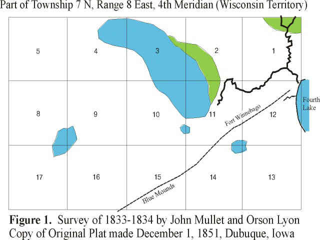
The first detailed map of this area was part of the original U.S. Land Survey by Mullet and Lyon in 1833-1834. (See Figure 1) "Fourth Lake," on the eastern side of the map, is Lake Mendota. Woods were in the green areas and wetlands in the blue. Lyons also describes several areas of prairie and an upland oak savanna. The old lake bottom was about 90 feet above Fourth Lake's level, and the valley of what became Pheasant Branch is clearly shown extending from a location near present-day Highway 12 to the lake.
Ligowsky compiled the next detailed map of the same area in 1861, 27 years after the land survey. (See Figure 2) Ligowsky's map is unusually informative. It gives the names of property owners, and uses hachure lines to provide information about topography. Two railroads reached Madison in the mid-1850s and were later combined into one new company. A railroad right-of-way, shown as an unlabeled dotted line on the map, marks the intended route for the yet-to-be-named company.
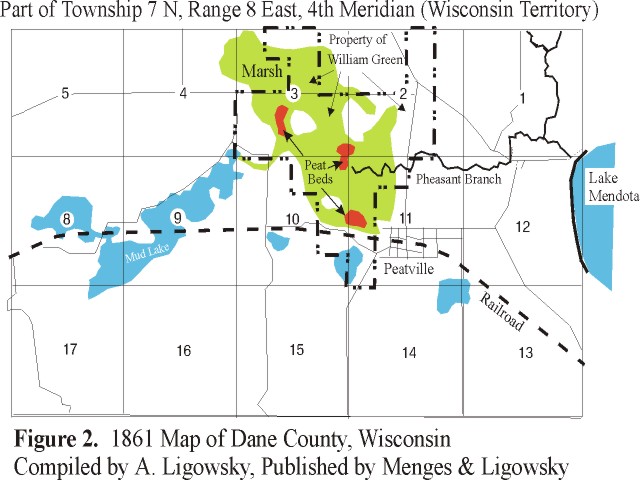
Peatville, a community established in 1856, became Middleton Station in June 1862, Mendota in July 1862 , and finally Middleton in 1870. Burgess C. Slaughter, Peatville's first postmaster and probably its founder, had an interest is digging peat. Three separate "peat beds" are seen on the 1861 map. (Peat, a deposit of un-decomposed plant debris, is not preserved unless it is kept below the water table away from oxygen.)
It appears from Ligowsky's map that the Pheasant Branch channel was altered from its 1833-1834 position in order to draw down the watertable and harvest peat from the three beds, possibly as early as 1856 when Peatville was established. Some time before the 1861 map was compiled, a William Green purchased 1,120 acres of land in sections 2, 3, 10 and 11 (the boundary is represented by the dashed lines on the map). His purchase represents a large portion of the old lake bed. Though marshland, it must have cost a considerable sum.
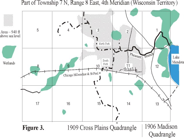
The series of ditches we see today were carrying drainage water from the old lake bed into Pheasant Branch and Lake Mendota by the mid-1800s. These drainage channels are evident on a sketch of 1906 and 1909 topographic quadrangles shown in Figure 3. Note how the North and South Fork of Pheasant Branch passes exactly through the "peat beds" of Figure 2.
Appendix 4: Land Engineering as a Water Management Technique
The Lake Mendota Priority Watershed includes 146,000 acres of land, 49 miles of streams and 10,025 acres of lakes. Wetlands, although reduced to 11 percent of the surface area, are still a significant natural resource for protecting water quality in the watershed. Streams and lakes in distressed watersheds have low dissolved oxygen and high bacteria levels. They support fewer fish and wildlife, but have many more nuisance aquatic plants, such as algae. Such conditions prevail in the Lake Mendota Watershed.
Urbanization increases sediment and chemical pollutants in stormwater runoff, aggravating water quality problems. Construction site erosion during development is a major source of sediment and phosphorous pollution. After development, contaminants that threaten water quality include oil, grease and chloride and heavy metals such as copper, zinc, cadmium, chromium and nickel.
A proliferation of roads, parking lots and buildings prevent absorption of rainfall and melting snow into the ground. As a result, urban growth reduces streamflow during dry periods. It also causes streambank erosion during storms and snow melts due to the increased volume and velocity of water runoff. Sediment from erosion degrades water quality and wildlife habitat in downstream marshes and lakes.
Water management techniques reduce erosion by increasing the ability of soils to absorb water. Absorption replenishes groundwater supplies and prevents soil loss. The ability of soils to capture, hold and absorb water can be significantly improved using the natural movement of water and existing land contours. Water management "structures," such as diversion terraces, small dams and grass waterways, disperse water horizontally. They slow runoff velocity, reduce its downhill force, and build permanent water retention and absorption capacity into fields.
Croplands and construction sites are both particularly vulnerable to erosion problems because soil is exposed. Erosion occurs when the kinetic energy or momentum of falling raindrops overcome the bonding forces of soil, causing small particles to break off. Some soils are more resistant to raindrop detachment than others due to the amounts of organic and inorganic colloidal materials they contain. Clusters of inorganic and organic particles bind fine soil particles into compound units of varying sizes. Without such bonding, these fine particles clog and seal the pathways through which water normally flows into the soil. Clear water penetrates into soils ten times faster than turbid water loaded with sediment. Conversely, soil surfaces encrusted with sediment effectively prevent water penetration.
Many Dane County farmers have used water management techniques for years. They know that fine soil particles enhance farm fertility, and soil loss reduces crop yields. They use water management structures to keep their soil where it belongs. For example, they contour terraces to create temporary pools of water on level surfaces. They use shallow ditches, or swales, cut along a hillside perpendicular to the flow of runoff to collect and hold water, slowing its downhill movement.
Construction site techniques to trap sediment and increase groundwater infiltration include:
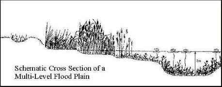
Wetland restoration is another valuable tool for improving water quality. Wetlands control erosion, reduce sediment runoff and prevent flooding. Wetland plants hold soil in place, preventing erosion during heavy rains storms. They also improve water quality because they take up nutrients; purify surface and groundwater supplies; and alter toxic pollutants chemically and biologically to reduce their ecological impact. In addition to providing wildlife habitat and recreational opportunities, restored wetlands have great aesthetic value.
For further information regarding land engineering for stormwater management, contact Aicardo Roa, Ph.D. at Dane County Land Conservation, 1 Fen Oak Court, Madison WI 53704 Telephone: (608)224-3743, Fax: (608)224-3745 or visit the internet Web site at www.nssc.nrcs.usda.gov
Appendix 5: Potential Funding Sources for Implementing Recommendations *
[ * Prepared by Andy Morton, Wisconsin DNR Southern District. ]
The Wetland Reserve Program is administered by the Natural Resource Conservation Service. It provides funding for easement acquisition, and restoration cost-sharing assistance for wetlands and riparian areas.
The Lake Mendota Priority Watershed Project is administered by the Dane County Land Conservation Department and the Department of Natural Resources. It provides cost-sharing assistance and will buy perpetual easements for streambank and wetland restoration. The program also provides funding and technical assistance for the design and installation of several other best management practices aimed at reducing non-point source pollution.
The Stewardship Program is administered by the DNR. It provides matching funding for the acquisition of land in several categories ranging from local park aids to streambank protection.
The U.S. Army Corps of Engineers Aquatic Restoration Program (206) provides technical assistance, and cost sharing for the restoration of aquatic habitats and land acquisition. Projects are evaluated on fish and wildlife benefits. Local sponsors can use in-kind services as part of their match.
Appendix 6: List of Committee Members (October 1998)

March 11, 2003
Please send corrections and/or comments to maher@geology.wisc.edu