THE EARLY HISTORY OF THE PHEASANT BRANCH WATERSHED, MIDDLETON, WISCONSIN
Louis J. Maher
Department of Geology & Geophysics
University of Wisconsin-Madison
1215 West Dayton Street
Madison, WI 53706
e-mail: maher@ice.geology.wisc.edu
Essentially all of Middleton Township (T7N, R8E) was covered by ice of the Green Bay Lobe during the last glaciation (Mickelson, 1983). The Johnstown Moraine, marking the lobe's maximum size, extends northwest-southeast through the village of Cross Plains. Meltwater flowed westward toward the Wisconsin River. The glacier began to waste away about 13,000 radiocarbon years before the present. By the time the ice had retreated to the site of present-day Middleton, a good-sized proglacial lake had formed in a bedrock lowland whose eastern margin was the glacier. The proglacial lake received sand, silt and mud from the meltwater, and it existed as a deep lake until the ice receded far enough eastward to open up lower drainage routes to the south. In 1995 Lee Clayton, Wisconsin Geological and Natural History Survey, drilled a 95 foot hole in the lake sediment in the NWĽ, SEĽ, Sec. 3, T7N, R8E (Core DN-1421b-F, Bruce Company property). At the core site the material is composed of sands and muds. I examined the pollen in an unoxidized sample at a depth of seven feet below the soil surface. Spruce pollen composed a quarter of the pollen sample whereas sedge and other herbaceous species made up half of the total. In this area abundant spruce pollen indicates the sample formed more than 10,000 radiocarbon years ago. The old lake flat existed as a poorly-drained region of open lakes and marsh throughout postglacial time.
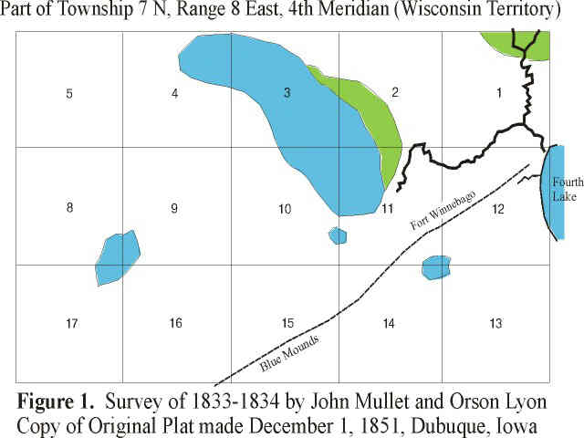
The first detailed map of this area was made as part of the original U.S. Land Survey of T7N, R8E, 4th Meridian (Mullet and Lyon, 1833-1834). A copy of the original plat was made at Dubuque, Iowa, in 1851. A sketch of the 15 sections in the northeastern part of the township is shown as Figure 1. "Fourth Lake" at the eastern side of Sec. 12 is Lake Mendota. The plat shows the old Blue Mounds-Fort Winnebago (Portage, WI) road. Woods are shown in green and wetlands in blue. Lyon's notes describe the southwest part of the township as hilly and the northeast part as rolling. "It is timbered with burr, white, and black oak, with an undergrowth of grass." He describes several areas of prairie. The upland would best be characterized as an oak savanna. The floor of Glacial Lake Middleton is the blue area in sections 2, 3, 4, 10, and 11. It is of interest that the valley of what became Pheasant Branch Creek is clearly shown to extend headward to near the center of Sec. 11 (near the location of today's Highway 12). The old lake bottom is about 80 feet above the level of Lake Mendota. Pheasant Branch apparently eroded headward into the old lake flat during the postglacial interval--perhaps aided by spring sapping when the valley reached the permeable sandstones under the Quaternary sediments.
Ligowsky (1861, see Figure 2) compiled the next detailed map of this area about 27 years after the land survey. The whole area had been settled by this time. The "Milwaukee and Mississippi Railroad Company" reached Madison in 1854 and Prairie du Chien by 1856 (Anonymous, 1880, p. 174). In 1859 and 1860, the company defaulted on its bond interest payments and was foreclosed; a new company called the "Milwaukee and Prairie du Chien" took over its rights and property. The railway right of way is shown by an unlabeled dashed line on the 1861 map of Ligowsky; perhaps the new name was not yet known when the map was compiled.
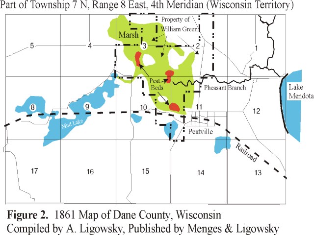
The Ligowsky map is unusually detailed and informative. It contains the names of all the property owners, and it uses hachure lines to provide information about the topography. The site of present-day Middleton is labeled as Peatville, a community established on December 10, 1856 (Cassidy, 1947), with the coming of the railroad and the platting of the village. The name was picked by Burgess C. Slaughter, who served as its first postmaster. (Peatville became Middleton Station in June 1862, then Mendota in July 1862, and finally Middleton in April 1870.)
Burgess C. Slaughter had an interest in digging peat, and three separate areas of "peat beds" are shown on Ligowsky's 1861 map (Fig. 2). Peat--a deposit of undecomposed plant debris--is interesting material. It is not preserved unless it is kept below the water table away from oxygen. One normally never encounters peat until the watertable is lowered. The Ligowsky map makes it very clear how the peat workings were established. The headwaters of Pheasant Branch had been considerably altered from their mapped position of 1833-1834. Rather than flowing north from near the center of Sec. 11, they now start near the peat beds in the extreme northwest corner of the section. I infer that the area's watertable had been drawn down sufficiently, at least by 1856 (Peatville's establishment), so that peat beds could be worked in at least three areas on the old flat of Glacial Lake Middleton. The Ligowsky map also provides a further tantalizing bit of information. Sometime before the map was compiled, a William Green had acquired 1120 acres of land in sections 2, 3, 10, and 11. This land (see dashed outline on Fig. 2) represents a large portion of the old lake bed. Did this William Green acquire the property with the idea of draining it to sell as farmland? It must have taken a considerable sum to purchase 1.75 sections of land--even of marshland.
William Green's name does not appear on a 1873 Atlas of Dane County (Anonymous, 1873); his holdings had all been sold to others. There is no indication of the marsh that was shown in the 1861 map. The whole southern half of Sec. 3 is shown to be the property of a W. B. Slaughter, probably a relative of the Burgess C. Slaughter who named Peatville.
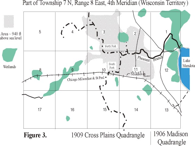
It is safe to conclude that Pheasant Branch was carrying drainage water from the marsh by the middle of the Nineteenth Century. I am sure the whole of the old lake floor had been made tributary to Pheasant Branch by the series of ditches that we see today--and which are manifest on the sketch of the 1906 and 1909 topographic quadrangles shown in Figure 3. Note how the north and south forks of Pheasant Branch pass exactly through the "peat beds" of Figure 2.
Anonymous. 1873. Atlas of Dane County, Wisconsin. Published by Harrison and Warner.
Anonymous. 1880. History of Dane County. Western Historical Company, Chicago, Part I.
Cassidy, F. G. 1947. The Place-Names of Dane County, Wisconsin. American Dialect Society, n. 7.
Ligowsky, A. 1861. Map of Dane County, Published by Menges & Ligowsky.
Mickelson, D. M. 1983. A Guide to the Glacial Landscapes of Dane County, Wisconsin. Wisconsin Geological and Natural History Survey, Field Trip Guide Book 6, 53 p. (Map in folder).
Mullet, J. and Lyon, O. 1833-34; 1851. Government Land Survey of T7N, R8E, 4th Meridian, Wisconsin Territory.
October 19, 1998