Purpose: This Web site provides access to up-to-date velocity field maps and station coordinate time series for WISCORS, which is a network of continuous GPS stations funded by the state of Wisconsin. The station time series and accompanying maps are updated daily and produced at the Department of Geosciences of the University of Wisconsin-Madison. Further information about the raw GPS data analysis and results posted at this Web site are given below.
Wisconsin DOT/UW-Madison partnership:The Wisconsin DOT operates software that continually monitors the operational status and quality of data at the WISCORS stations. Independent analysis of the same data by the Department of Geoscience at UW-Madison provides a different and complementary picture of the quality of the incoming data and long-term stability of the station monuments. To date, this has helped identify slow equipment failures at several WISCORS stations and is increasingly defining the long-term noise and stability characteristics of the WISCORS sites.
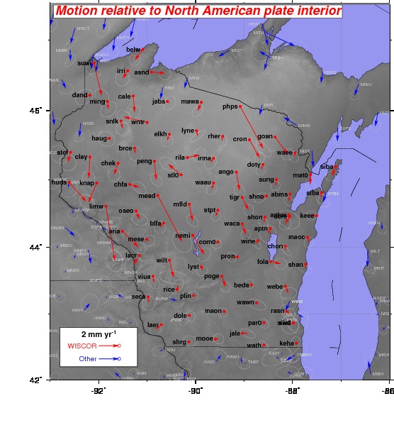
Applications: Although the primary applications of the WISCORS GPS network are in the commercial sector, including construction, surveying, and transportation, the WISCORS data are also useful for a variety of practical and scientific purposes. For example, GPS can be used to study the movements of the tectonic plates and the slow rebound of interior areas of North America in response to melting of the thick ice sheet that loaded much of North America during the last ice age. Some of the maps that are accessible via links located in the left-hand column of this Web page show North American plate movement using GPS (including at WISCORS stations).
GPS is also sensitive enough to identify places where ground subsidence may be occurring in response to over-pumping of groundwater. Such subsidence can cause cracks in buildings and important infrastructure such as roads and bridges and may be a sign of unsustainable use of valuable groundwater resources. All of these applications require a high level of precision and thus a more involved process for processing and using the WISCORS data.
Information: Each day, an automated GPS data processing routine at the UW-Madison Department of Geoscience retrieves and processes WISCORS GPS data files from a Wisconsin Department of Transportation server. Processing of the WISCORS data with state-of-the-art GIPSY analysis software from the NASA Jet Propulsion Laboratory yields a precise estimate of the daily position and elevation for each station, typically accurate to within 2 millimeters in the north and east directions and 4 millimeters in the vertical. After the raw processing is complete (typically within a few hours) additional post-processing procedures are used to refine the position estimates, which further improve the precision in the estimated station location to 1 millimeter in the north and east and 3-4 millimeters in the vertical. These optimized daily station locations are then used to determine best estimates of the motions of the WISCORS and other sites, examples of which are provided through the options menu at the left. Up to date results are generated and saved each day for nearly 4000 stations globally.
 Contact: Professor Chuck DeMets: chuck@geology.wisc.edu