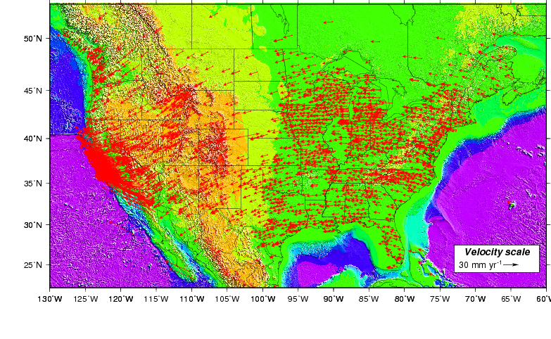
Source: This map is updated daily by C. DeMets of UW-Madison from GPS station
velocities determined at the UW Department of Geosciences. The map is created using Generic Mapping
Tools software.
Upper map: The station motions in the upper map show how continuous
GPS stations in the United States and vicinity move with respect to an international Earth-based
reference frame called ITRF2008. The systematic counterclockwise motion (rotation) of the
stations illustrates the expected rotation of the North America tectonic plate about its
pole of rotation, which lies just south of the edge of the map near 270 degrees east longitude.
Mathematically, it is easy to select all GPS stations from the rigid interior area of the
plate and use them to find the pole of rotation and rate of angular rotation that best
describe the
measured GPS station rates and directions (the GPS site velocities).
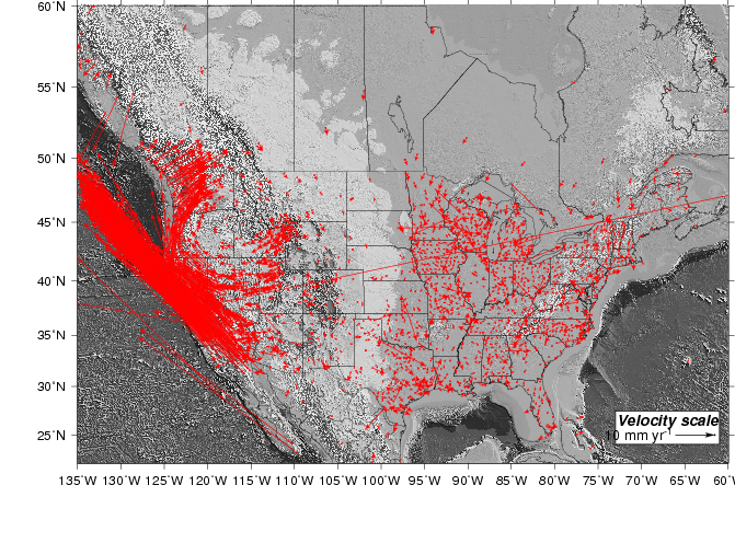
Lower map: Given the North America plate rotation described above,
one can easily change the frame of reference for GPS sites shown in the map to one in which
the North America plate interior does not remove (i.e. the influence of the rotation is
removed). To do so, the best-fitting plate rotation is first used to estimate the plate's
motion at the location of each GPS site in the United States. Those estimates are then
subtracted from the measured velocity of the GPS site, thereby removing the influence of
North America plate motion at each site. The remaining "residual" site velocities
mostly show random and other noise that affects daily estimates of the location of each
GPS antenna. However, the residual velocities can reveal patterns of
movement within a tectonic plate interior. Examples include the slow southward movement
of stations in Canada and the north-central and northeastern United States in response to ice
sheet unloading of these areas at the end of the last ice age (roughly 10,000 years ago) and
motions of stations near active plate boundary faults in the western United States.