SLIP Overview
CUTLER, Paul M., Dept. of Geology and Geophysics, Univ. of Wisconsin, Madison, WI 53706, MACAYEAL, Douglas R., Dept. of Geophysical Sciences, Univ. of Chicago, IL 60637; COLGAN, Patrick, M., Geology Dept., Northeastern Univ., Boston, MA; MICKELSON, David M., Dept. of Geology and Geophysics, Univ. of Wisconsin, Madison, WI 53706
This NSF-funded project integrates the disciplines of glacial geomorphology, hydrology and glaciology in an attempt to unravel the major influences on ice-sheet dynamics, regional hydrology and landform generation around the southern margin of the Laurentide Ice Sheet (LIS) from about 55 - 10 kyr B.P. Using glacial geologic and paleoclimatic information as constraints on an ice-sheet model, Paul Cutler is working with Doug MacAyeal (U. Chicago) to adapt a two-dimensional time-dependent ice-sheet model to incorporate raw geologic information such as bedrock characteristics and topographic roughness. Treatment of permafrost dynamics, subglacial hydrology and basal motion are also aspects of the model that are currently, or will soon be, receiving attention. A preliminary example of the model, with some diagnostic parameters, can be found by clicking MODEL. Dave Mickelson and Pat Colgan (Northeastern University), graduate student Kelly LeBlanc and Paul Cutler are organizing (i) glacial geologic information (distribution of landforms), (ii) associated information on chronology, where available, and (iii) spatial lithologic trends into a geographical information system (GIS). In the GIS environment it becomes easier to identify causal relationships between various layers of information. We are also developing mapping techniques using digital elevation models in tandem with digital topographic maps to speed up the process of gathering landform information. Through a combination of the GIS approach and the numerical modelling we anticipate being able to make well-constrained assessmentsof (i) physical conditions responsible for the formation of landforms, (ii) subglacial water drainage patterns, and (iii) ice dynamics from 55,000 to 10,000 BP. Overall, we are making significant strides towards constraining the glaciological, hydrological and geomorphic evolution of the southern Laurentide Ice Sheet and its environs.
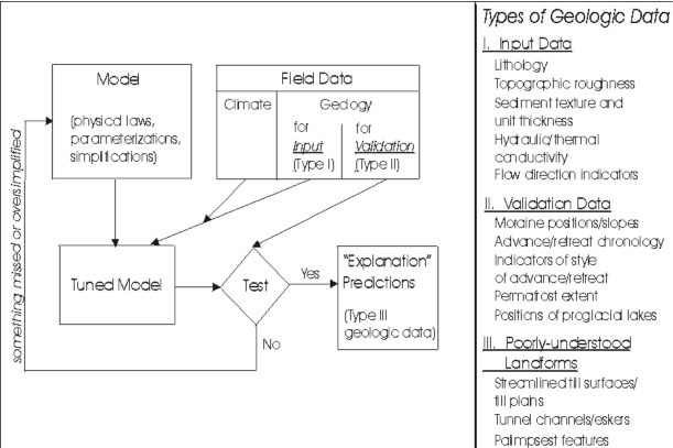
A flow diagram illustrating our approach to the project is given below. This diagram was adapted from ideas of Terry Hughes.
|