Welcome to the Glacial Geology Home Page
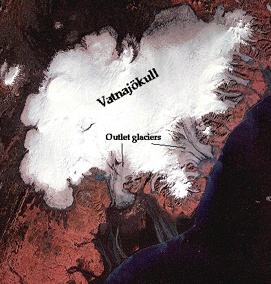 Landsat 1 MSS image of Iceland's largest (8,300 square kilometers) ice
cap, Vatnajokull (Taken from USGS Fact Sheet 009-94,September 1994 at The
USGS Glacier Images Atlas. Notice the snow line,and the small outlet
glaciers draining from the main ice cap. The small outlet glaciers (valley
glaciers) are gray (bare ice, ablation area) instead of white (snow, accumulation
area). The dark black lines seen on some of these outlet glaciers are medial
moraines. Also notice the braided stream system developed on the outwash
plain (black areas in front the outlet glaciers), and sediment plumes along
the coastline. These sediment plumes are created as silty glacial meltwater
streams enter the Atlantic. The depression in the ice (SW of the V in Vatnajokull)
is above the active volcano, Grimsvotn. This depression is a lake formed
from enhanced basal melting around Grimsvotn. Water builds up in the lake,
and periodically catastrophically drains a Jokulhlaup (glacial burst)
event.
Landsat 1 MSS image of Iceland's largest (8,300 square kilometers) ice
cap, Vatnajokull (Taken from USGS Fact Sheet 009-94,September 1994 at The
USGS Glacier Images Atlas. Notice the snow line,and the small outlet
glaciers draining from the main ice cap. The small outlet glaciers (valley
glaciers) are gray (bare ice, ablation area) instead of white (snow, accumulation
area). The dark black lines seen on some of these outlet glaciers are medial
moraines. Also notice the braided stream system developed on the outwash
plain (black areas in front the outlet glaciers), and sediment plumes along
the coastline. These sediment plumes are created as silty glacial meltwater
streams enter the Atlantic. The depression in the ice (SW of the V in Vatnajokull)
is above the active volcano, Grimsvotn. This depression is a lake formed
from enhanced basal melting around Grimsvotn. Water builds up in the lake,
and periodically catastrophically drains a Jokulhlaup (glacial burst)
event.
Tom Lowell at the University of Cincinnati has designed a page
for his glacial geology course. There are many nice images of glaciers
and glacial features. Here's
a link to his page.
Last updated by David Mickelson, January 12, 1999.