Purpose: This Web site provides access to up-to-date velocity field maps and station coordinate time series for a 13-station continuous GPS network operated by Jamaica's National Land Agency, complemented by data from three continuous stations operated by UNAVCO of Boulder, Colorado as part of the Caribbean-region COCONet cGPS network and two continuous stations operated since 2003 as part of a long-term study by Jamaica's Earthquake Unit (University of West Indies-Mona) and the University of Wisconsin-Madison.
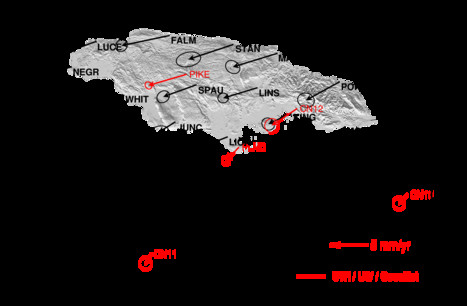
Applications: Although the primary applications of the Jamaica National Land Agency GPS network are commercial, their GPS data are also useful for scientific purposes. In particular, continuous GPS data are used in nearly all areas prone to earthuakes because they track movements of Earth's crust as slow as 1 millimeter per year. The island of Jamaica is located at the northern edge of the Caribbean plate, where a series of active but poorly understood faults in Jamaica and in nearby offshore areas are located. These faults spend nearly all their time locked by enormous frictional forces, punctuated every few centuries by magnitude 7 earthquakes that relieve the pent-up strain. Studying these processes with GPS requires a high level of precision and hence an exacting procedure for processing the raw GPS data.
Project history: In January of 1999, the Earthquake Unit, then headed by seismologist Dr. Margaret Grandison, began working with Professor Chuck DeMets, a geophysicist at the University of Wisconsin-Madison to use GPS to study these poorly known faults in order to better understand earthquake hazard in Jamaica and the long-term geologic evolution of the island's major geographic features. Funded by the U.S. National Science Foundation, this study has continued without interruption since then. Over the past 14 years, Paul Williams, an employee of the Earthquake Unit, has assembled a remarkable set of GPS data through annual measurements at approximately 20 GPS stations on the island. The effort presently continues under Lyndon Brown's leadership at the Earthquake Unit.
GPS data processing: The GPS station time series illustrated at this web site and the accompanying maps are updated every few weeks by Professor DeMets. The raw GPS data are processed at UW-Madison with state-of-the-art GIPSY analysis software from the NASA Jet Propulsion Laboratory. The processing yields a very precise estimate of the daily position and elevation for each station, typically accurate to within 3 millimeters in the north and east directions and 6 millimeters in the vertical. Following the raw processing, additional procedures are used to estimate and correct for noise. These further improve the precision in the estimated station location to 1-2 millimeters in the north and east and 3-5 millimeters in the vertical. These optimized daily station locations are then used to determine best estimates of the motions of the Jamaica NLA GPS sites and other sites,

 Contact: Professor Chuck DeMets: chuck@geology.wisc.edu