Western Water, Expansion of the West, Flood, Hydroelectric
Power, and Conflicting Values
The Colorado River Flood Experiment
(March-April 1996)
TWO TOPICS FOR DISCUSSION
(1) HISTORY AND SIGNIFICANCE OF GLEN CANYON DAM
(2) THE 1996 FLOOD EXPERIMENT
Good Reading
Martin, R. (1989) A Story That Stands Like a Dam; New York, Henry
Holt.
Reisner, M. (1986) Cadillac Desert; New York, Viking Press.
McPhee, J. (1971) Encounters with the Archdruid; New York, Farrar,
Straus, and Giroux
BACKGROUND
AND HISTORY
- 1- Role of Colorado River in western water development and development
of the american west
- 2- Construction Glen Canyon dam (1956-64)
- 3- Importance of Lees Ferry (mile zero)
- Boundary (upper & lower basin)
- 4- Changes in the Grand Canyon since dam construction
WESTERN WATER
- Water right principles First in time, first in right
- Limits of growth in arid region and need to buffer draught.
- Reclamation act of 1902
- Interest free loans with long payback times
- Designed to encourage agricultural settlement in western regions of
U.S.
- Addl. loans and delay of paybacks in acts of 1910, 1911, & 1939
California is First in Line, but ...
- Wrangling over California attempts to take all water for Southern California
- Unsuccessful efforts to control floods
- Congress demands western states to negotiate.
- Settled by the Colorado River Compact of 1922
1922 Colorado River Compact
- Divided Colorado into two basins
- Upper Basin States (CO, NM, UT, WY)
- Lower Basin States (CA, AZ, NV)
- Dividing line established as Lees Ferry, AZ
- River miles measured from Lees
Ferry
- Positive (+) miles downstream
- -Negative (-) miles upstream (Glen Canyon dam is at -15 mile point
on the Colorado River)
- Water Allocation
- Assumed annual flow @ L.F. is 16 million acre feet (maf) [16 maf =
41,400 cfs]
- Allocated 7.5 maf each with 1.0 maf ìsurplusî
- Neither native americans nor Mexico involved, but provisions made for
later treaty negotiations
1 million acre feet = 39.5 miles on a side & 1 ft deep = 2.44 x
1012 gallons
7.5 maf/year = 10,350 cfs (cubic feet per second)
A PAPER ACT
- Only provided paper water
- Required Congress to appropriate funds
- Forged the IRON TRIANGLE of Congress, the Basin States, and the Bureau
of Reclamation.
- Rise of Floyd Dominy at Bur. Rec. and the era of dam building Glen
Canyon Dam the culmination.
WATER PROBLEMS
- Between 1906 and 1947 only 14.2 maf/yr passed Lees Ferry and in the
30s only an average of 10.2 maf/yr. [1.8-5.8 maf short!]
- Solution: Build a dam at Lees Ferry and use it to store water from
wet years, thereby meeting Lower Basin obligations and providing ìpotentialî
water for Upper Basin development
- Glen Canyon dam became the Cash Register for Upper Basin water development.
FIVE TIME DOMAINS OF RIVER FLOW FROM THE DAM
- 1- ETERNITY: Interbasin allocations
- 2- INDETERMINATE: To protect endangered species
- 3- DECADAL: Upper Basin delivery obligations
- 4- YEARLY: L. Powell fill and division of water between L. Mead and
L. Powell
- 5- DAILY: Power generation demands (Western Area Power Association)
CONFLICTING VALUES
Conflicting multiple role for Glen Canyon Dam
- 1- Power generation
- 2- Lower Basin water delivery
- 3- Water for Upper Basin development
- 4- Flood control
- 5- Recreational Use (Lake Powell, AND the river below the dam)
- 6- Environmental protection of native species
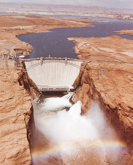
GLEN CANYON DAM
- Started in 1956
- Completed in 1964
- Filling delayed over several years to meet demands for Hoover (Boulder)
Dam
- 1983 Flood and near disaster
CHANGES SINCE THE DAM BUILT...
A Modified River since Glen Canyon Dam Construction
- Silt now trapped in upper Lake Powell
- Release of cold, clear, deep water from the dam to the reach between
Glen Canyon and Lake Mead
- Introduction of non-native trout and threat to native species (humpback
chub, bonytail, razorback sucker)
- Growth of riparian vegetation (esp Tamarisk or salt bush the ìweed
of the westî)
- Loss of sand bars from Grand Canyon reach
- Changing habitat of native fish and their food resource
- Clogging of river at entry points from major sediment laden streams
(Paria, Little Colorado)
- Growing recreation pressure on use of the park's facilities
- Growing environmental awareness
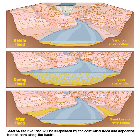
Flood Proposal
(> 2 yrs in planning)
- Need to move the river back toward pre dam conditions.
- Demonstrate that sand can be redistributed and that lost beaches can
be renewed
- Demonstrate an improved habitat for fish, birds, mammals, reptiles,
plants, .....
- Demonstrate minimal effect on sport fishing activities in the ìtailwaterî
reach of the dam
- Justify cost of experiment against loss of revinue from dam power generation
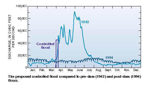
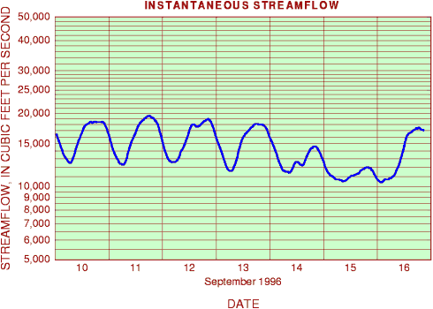
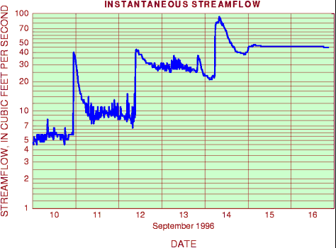
HYDROGRAPHS
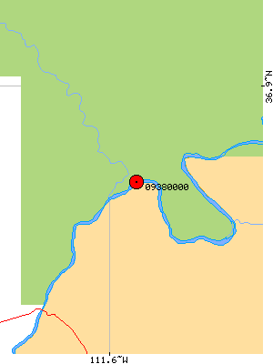
LEES FERRY AREA
CUTOFF OF SAND BY LAKE POWELL
- How do we replace the sand thatís cut off from the Upper Colorado
River?
Where does the sand come from?
- 85 million tons/yr trapped in upper Lake Powell from Green, Colorado,
and San Juan Rivers
- 16 million tons/yr supplied by Paria and Little Colorado River below
Glen Canyon (~20% of total sediment)
- Estimated that a 45,000 cfs flood would move less than the 16 million
tons leading to a net accumulation in the lower Colorado River
- A 95,000 cfs event (pre-Dam) would remove much more, but max from Glen
Canyon dam is now 45,000 cfs (w/o use of spillway)
- Claimed that sediment from the Paria and Little Colorado will replace
the lost sand, PROVIDED that a 45,000 cfs flood can be used to clear and
redistribute the sediment.
Without periodic floods the sand will move off the shores and into deeper
water and clear the loads dumped at Little Colorado River that are presently
creating worse rapids than pre dam conditions
THE PROPOSED FLOOD
USGS Fact Sheet [link to USGS Fact Sheet]
- DEPARTMENT OF THE INTERIOR
- USGS:
U.S. Geological Survey
- USBR: Bureau of Reclamation
- GCES: Glen Canyon Environmental Studies
- NPS: National Park Service
- BIA: Bureau of Indian Affairs
- USFWS: Fish and Wildlife Service
- AG&F: Arizona Game and Fish Comission
- WAPA: Western Area Power Administration
- Navajo Tribal Council
Sand Redistribution Scenario
Hydrograph and Lake Level
PRELIMINARY
RESULTS
- A Qualified Success
- Saddle Beach Area (illustrated)
- Little Colo River Junction
Ongoing
Activities
Will the flood experiment be repeated?
Will perodic "flood" release become a regular part of dam
management
Press Release from Secy.
Babbitt (10/17/96)
Note: All illustrations linked to this page are courtesy of the U.S.
Geological Survey. We encourage you to pursue the USGS links, especially
their "Fact Sheets". The "ongoing activities" and USGS
links on this page provide direct links to the USGS and you should be able
to explore from there. Several items of interest to environmental geology
are available through these pages.