Mountain ranges of the western United States
Western North America is one of the most extensive mountainous regions on
Earth, with mountainous topography extending north-to-south for
thousands of miles (from northern Alaska to southern Mexico) and east-to-west
for roughly one thousand miles at the latitude of Colorado. The western
United States alone has hundreds of individual mountain ranges, too many to
explore thoroughly in a single lifetime. Uplift of these mountain ranges
did not occur during a single geologic period, but instead occurred at different
times in the geologic past in response to the ever-changing plate tectonic
forces that were being exerted along the western edge of the North American
plate. Rocks in some mountain ranges were deformed by multiple plate
tectonic events, giving rise to a relatively complex record of rock deformation
that geoscientists have been working to decipher for more than 150 years.
As an introduction to mountains of the western United States, this lecture
(and one subsequent lecture) provides basic information about the key formative
events of several major geotectonic province of the western United States.
A "geotectonic" province is defined here as a geographic region whose
mountain ranges (or more generally rock structures) share a common originating
cause. For example, active mountain building in western California is
almost entirely attributable to active slip along the San Andreas fault and
related faults, thereby leading geoscientists to define a geotectonic province
associated with the San Andreas fault. Mountain ranges within a particular
geotectonic province are likely to have undergone uplift during roughly similar
times, although such uplift could have occurred over periods of tens of millions
of years.
Orogeny
refers to the process of mountain building. Distinct orogenic
events are frequently assigned names by geoscientists to help organize information
about the mountain building history of a particular region. A particular
orogeny refers to mountain building (or more generally, rock deformation)
that occurred in a particular region during a particular period in the geologic
past. Mountains, once built, can be deformed by later orogenies that
are caused by different sets of tectonic forces that act on the crust.
The goals of this lecture are threefold:
- Outline basic features of several major geomorphologic/tectonic provinces
of the western United States
- Discuss the age that each of these areas last experienced major deformation
(mountain building or volcanism)
- Show reconstructions of how the western United States looked at pivotal
points in the past 100 million years and discuss how changes in the plate
tectonic setting of the western United States have profoundly influenced its
geologic history.
Let's first review the locations and ages of the major geotectonic provinces
of the western United States.
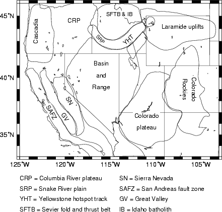
A list of most of the major provinces and their principal formative ages
follows
-
Basin and Range province - 17 Ma to present;
Arizona to Mexico - some extension as early as 30 Ma, with major pulses
at 24-23 Ma and 13-12 Ma. Extension today in the southern areas of
the Basin-and-Range is slow or inactive. Extension across the northern
Basin-and-Range (Nevada/Utah/eastern California) occurs at rates of
roughly 11 millimeters per year (1/2 inch per year).
-
Cascade volcanos - active through the present-day.
Volcanism associated with subduction of offshore oceanic plates beneath
the Pacific Northwest has been ongoing, with some quiet periods, for
at least 30 million years.
-
Colorado Plateau - some uplift since 30 Ma, with
main pulse (4000-6000 feet) of uplift in the past 5 Ma.
-
Colorado Rockies- some Laramide age uplifts in
central and southern Rockies and igneous activity and volcanism during
Laramide up through 25 Ma. . In southern Rockies, locally extensive
volcanism from 40-25 Ma.
- Laramide uplifts - 75 Ma - 40 Ma
- San Andreas fault zone and related features - Roughly 15 million
years ago to present
-
Sevier fold-and-thrust belt and Idaho batholith
- 105 Ma-75 Ma - overlaps Laramide
-
Sierra Nevada mountains - igneous rocks formed
primarily from 120 Ma-80 Ma; however the mountain range was uplifted
to present levels primarily in the past 5 Ma.
-
Yellowstone Hotspot/Snake River plain/Columbia
Plateau - presently active; Snake River plain - 16 Myr - present
progressively younger as it approaches the Yellowstone hotspot;
Columbia River plateau - 17 million years old.
Present-day tectonic and volcanic activity
Earthquakes, deformation, and volcanism in the western United States are
largely focused along the San Andreas fault zone, and in Cascadia, Yellowstone,
and the northern Basin-and-Range province.
Present mountain range morphology/physiography
The present physiographies of the mountain ranges and landscape in the major
geologic provinces are not only profoundly influenced by their tectonic
origins and properties of the rocks they are made of, but are shaped by
erosional processes and the present and past regional climate. It is thus
important to recognize that once the formative stages (orogenesis) of the
mountain range are finished, much of their subsequent geologic evolution
is dictated by non-tectonic factors. These processes are featured in later
lectures.
The Past 100 Ma
The geologic history of a region as large as the western United States
is not easily summarized for a period as long as 100 million years; however,
there are several general comments and two diagrams that provide useful
backdrops against which to view the major geologic events during this period.
The key observation is that prior to the initiation of the San Andreas
fault system at roughly 15 Ma, the plate tectonic setting of the western
U.S. was dominated by subduction toward the east of one or more oceanic
plates beneath the continent, the Farallon plate prominent amongst them,
. The convergence of these oceanic plates with the western edge
of the North American plate profoundly influenced volcanic and igneous
activity west of and including Colorado, and caused mountain building
(orogenesis) in the same region. The only major geomorphic features in
the western United States that are NOT likely to be caused by subduction are
the Columbia plateau volcanics, the Snake River plain, the Yellowstone
hotspot, and the San Andreas fault zone. A hotspot in the mantle beneath the
North American continent is the most probable cause of the Columbia plateau
and Snake River plain volcanics, as well as geothermal activity and volcanism
in and near Yellowstone National Park. Mountain building and faulting along
the San Andreas fault zone are caused by transcurrent, northwest-directed slip
of the Pacific plate past the North American plate in western California.
Volcanic history
The above diagram, which is taken from Atwater (1989), shows the
ages and locations of volcanic and igneous activity in the western U.S. over
the past 100 Ma and how the location of volcanic activity has changed location
through time. Each dot in the left hand plot shows the absolute age of
a volcanic or igneous rock that is located within the broad east-west zone
that is depicted in the panel at the right. An absence of age dates for a
particular time and geographic area implies an absence of volcanic and igneous
activity. The left-hand plot shows that from 100-80 Ma, volcanic and igneous
activity within an east-west belt south of Idaho and north of central Arizona
was limited
to the Sierra Nevada belt of eastern California and western Nevada. At
the beginning of the Laramide orogeny (roughly 70 Ma), volcanic activity
in this belt suddenly ceased and jumped far eastward into the continent,
to Colorado. At the same time, the Laramide uplifts of northern Colorado,
Wyoming and Montana, starting going up. These ranges are/were located a
remarkably long distance from the then-western coast of the North American
continent, where subduction was occurring, as was the volcanic and igneous
activity in central/southern Colorado during this period. One plausible
hypothesis for the jump of volcanic and orogenic activity far into the
continent during this period is that the dip of the oceanic plate then
subducting off the west coast of North America became much shallower than
during the previous tens of millions of years, thereby pushing the locus
of active faulting and volcano-igneous activity far into the continent.
After 50 Ma, volcanic and igneous activity began migrating slowly back
toward the west coast and by 25 Ma, the vast majority of the volcanic and
igneous activity in the Colorado Rockies ceased. Uplift of the Laramide
mountain ranges also ceased by roughly 40-30 Ma. The coastward migration
of the volcano-igneous activity and cessation of Laramide uplift both suggest
that subduction of the oceanic plate resumed at a steeper dip after roughly
40-30 Ma. It is unclear why the elevations of the Colorado Plateau and
Basin-and-Range province began to increase in the past 15-30 million years.
This uplift might be an after-effect of the long period of unusually shallow
subduction during the Laramide orogeny, or could be related to the change
at 20-15 Ma in the nature of the plate boundary off the west coast from
a subducting (convergent) plate boundary (Farallon-North America) to a
transcurrent plate boundary (Pacific-North America). Regular subduction of
oceanic lithosphere continues to the present-day off the coasts of northern
California, Oregon, and Washington, where the Juan de Fuca oceanic plate
subducts and gives rise to the Cascade volcanic arc.
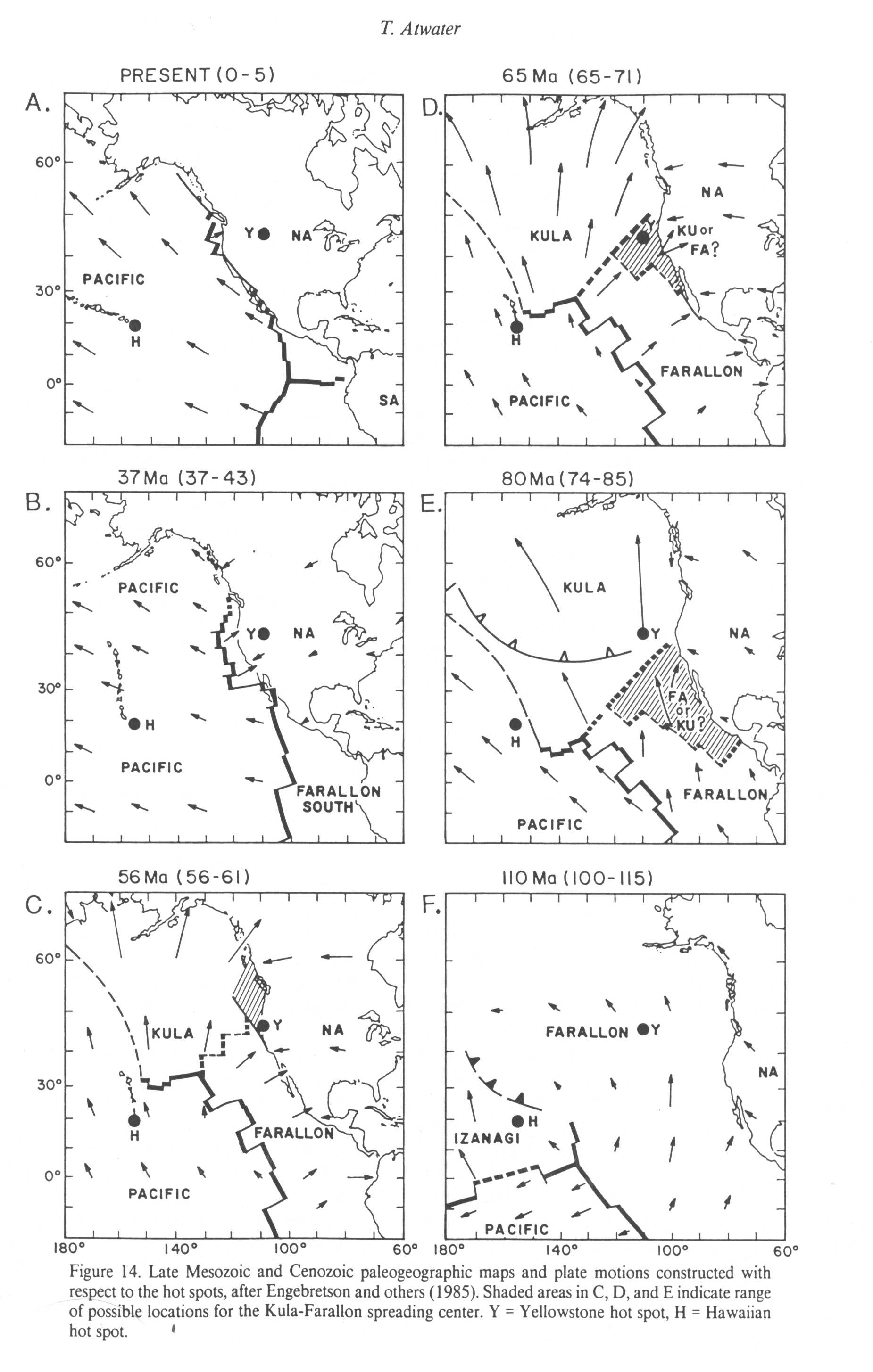
Plate tectonic history
The figure below, taken from Atwater (1989), shows the reconstructed positions
of the North American plate and oceanic plates in the Pacific basin over
the past 110 million years. The bold lines show the positions of seafloor
spreading centers. The oceanic plates adjacent to the west coast were subducting
to the east until roughly 15 Ma (not shown). Subduction of these plates
gave rise to the extensive and long-lasting volcanic and igneous activity
in the western United States, as well as the multiple phases of mountain
building evidenced by the numerous mountain ranges of the western U.S.
At roughly 20-15 Ma, the seafloor spreading center just west of North
America that is shown in the 37 Ma "panel" below intersected the western
margin of North America. Some of the seafloor spreading center subducted;
some "froze" offshore and thus became part of the Pacific plate, and some
of it is still active (the segment that separates the Pacific and Juan
de Fuca plates). Extinction and subduction of large segments of this seafloor
spreading center brought the Pacific plate into contact with North America
along the present San Andreas fault system, thereby giving birth to the
latest phase of mountain building and tectonic activity in the western
United States.
Reconstructions of the paleotopography and paleogeography
of the western United States
Professor Ron Blakey of Northern Arizona University has reconstructed
how the western United States looked at different times in the remote geologic
past by synthesizing a huge amount of geologic and other data collected by
himself and numerous other researchers. Below, I have selected a series
of graphics from his Web site for the last 100 million years and have written
some text to accompany each graphic (freely borrowing from Prof. Blake's text,
too). These reconstructions are subject to significant uncertainties, but
give you a flavor for how much change has occurred in the western United States.
Remember that the last 100 million years is just the most recent 2.5%
of Earth history.....
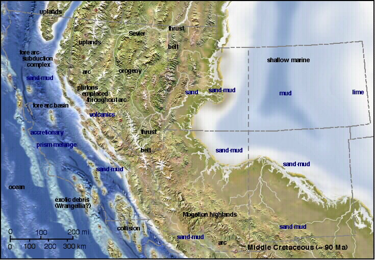
Western U.S. at 90 million years before present (below). Ninety million
years ago (90 Ma), the western U.S. didn't look much like it does today.
Relative to U.S. state borders (dashed gray lines), there was almost
no continent west of the California-Nevada border. A subduction zone
(trench) and sediments being scraped off the subducting Farallon plate
onto the edge of the continent were instead located where California is
now found. In addition, one of the Earth's largest ever intra-continental
seas (a shallow sea located within a continent) covered the central United
States from central Utah all the way to central/eastern North America. Thrust faulting,
convergence, and crustal uplift (orogenesis) were occurring in the Sevier
fold-and-thrust belt in response to subduction of the Farallon oceanic plate west
of the continent.
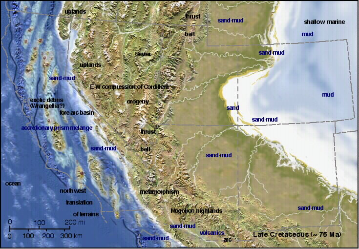
Western U.S. at 75 million years before
present (below). Fifteen million years after the prior scene, the interior
seaway had shrunk substantially, leaving enormous low areas of sea-bottom
and river-transported sand and mud in its wake. Some of the world's
greatest dinosaur remains are found in these deposits. Mountain building
associated with the Sevier orogeny reached its peak . Along the "West
Coast" subduction zone, the Farallon plate was converging at a low angle
with the coast, causing pieces of North America and other oceanic crustal
fragments to slide northwards along the western edge of the continent. Sediments
being scraped off from the subducting Farallon plate were complexly deformed
and accreted to the continent's edge. At least some of these complexly
deformed marine rocks are commonly exposed in the San Francisco region (and
many other areas of western California).
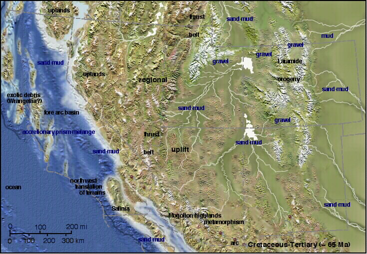
Western U.S. at 65 Ma (below). Between 75 Ma and 65 Ma, there were
enormous geotectonic changes in western North America. The continental sea
withdrew completely, and the Laramide orogeny began. With the formation
of the Laramide uplifts (discussed in a later lecture), many of today's most
beloved and recognized western U.S. mountain ranges were added to the landscape.
Volcanism in the Colorado Rockies also began during this period (see figure
farther above in this lecture), representing a huge eastward shift in the
location of volcanism prior to 75 Ma. A shallowing of the angle of
subduction of the Farallon oceanic plate under western North America is presumably
responsible for shifting subduction-related volcanism far eastward into the
Rocky Mountain region. Some evidence suggests that the collision of
a large and buoyant oceanic plateau on the Farallon plate with the subduction
zone resulted in Laramide-age mountain building and volcanism.
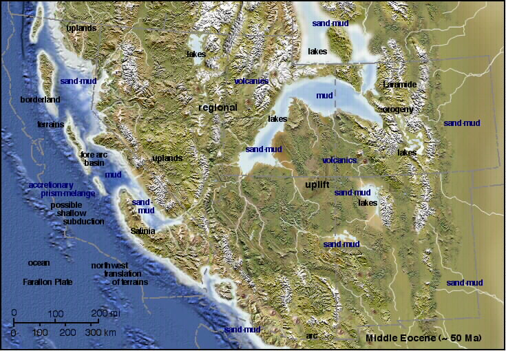
Western U.S. at 50 Ma (below). Laramide orogenesis continued during
this period. Large lakes formed in the basins located between the major
mountain ranges. As sediments eroding off the neighboring ranges poured into
these lakes, the basins subsided further, leading to very deep sedimentary
fill. Subduction of the Farallon plate continued during this period.
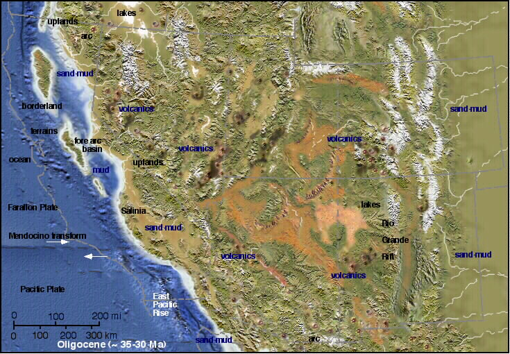
Western U.S. at 35 Ma (below). During this period, widespread volcanic
activity occurred (see the "volcanic history" figure earlier in this lecture),
predominantly due to the continued influence of Farallon plate subduction
along the west coast. As the subducting Farallon plate grew ever narrower,
the Pacific-Farallon seafloor spreading center neared the West Coast and brought
Pacific plate seafloor ever closer to contact with the western edge of North
America.
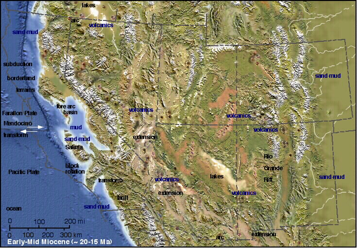
Western U.S. at 20 Ma (below). First contact of the Pacific and North
American plates occurred around 15 Ma because the Farallon plate had, by
this time, largely subducted into the mantle in the vicinity of California.
This change fundamentally altered the forces that were acting along the plate
boundary on the western edge of North America, with east-directed convergence
that prevailed during Farallon plate subduction changing to northwest-directed
Pacific plate movement parallel to the West Coast. The transcurrent San Andreas
fault of western California was born at about 15-12 Ma - northwestward movement
of the Pacific plate was accommodated in part by slip along the San Andreas
fault. Relaxation of the convergent stress regime associated with Farallon
plate subduction lead to widespread extension in much of western North America,
giving rise to Basin-and-Range uplift. Drainage systems of the Western Interior
were still not well integrated. Note the absence of a through going stream
on the Colorado Plateau. Subduction continued in northern California,
Oregon, and Washington, where the Juan de Fuca plate (a remnant of the Farallon
plate) continued subducting eastward beneath the coast. Interestingly,
there is little or no evidence from this time for the existence of the deep
canyons carved by the Colorado River. Notice that the Great Valley of central
California (just west of the Sierra Nevada Mountain Range) was an inland
sea at this time.
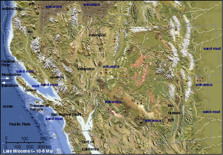
Western U.S. at 5-10 Ma (below). Basin-and-Range extension continued
during this period, as did volcanic activity in some areas. Significant
downward erosion of rivers into the Colorado Plateau began as the plateau
experienced net uplift of 4000-6000 feet.
The transition to an extension-dominated tectonic regime with an ever-decreasing
amount of volcanic activity was well underway, reflecting the change from
subduction-dominated to strike-slip dominated plate boundary motion along
the West Coast.
Today's western U.S.(below). Based on the images and descriptions
given above, I hope that you now see the present topography of the western
U.S. as the product of a long and complex geotectonic past, rather than an
unchanging, fixed landscape. Assembling the details of the geologic history
of the western United States from an eroded, multiply deformed, and largely
buried rock record is a difficult task, one that will undoubtedly continue
for many decades..