Underneath the mountains
I. Introduction
II. Buoyancy, Archimede's principle, and evidence for mountain roots
III. The lifetimes of mountain ranges
Appendix:
Beyond the intro level
I. Introduction
Over geologic time, the earth's mantle behaves like
a
highly viscous fluid (i.e. a fluid that flows very slowly). When
topography
is created on the earth's surface through crustal thickening, the
mantle
slowly flows out from beneath the thickened region so as to compensate
for the change in the weight of the overlying crust. The mantle thus
behaves
in a manner similar to that of water when a cube of ice is placed on
its
surface - water beneath the ice flows outward and upward and the ice
sinks
downward until an equilibrium (steady-state) is reached. There is
however
one important difference - on earth, the strength of the crust itself
helps
to support some of the weight of a topographic load. We must then study
two processes to develop a better understanding of how topography is
"maintained"
on our planet. One is buoyancy and the other, flexure.
II. Buoyancy
Suppose we floated a block of ice in a tub of cold water and asked the following question: How much of the block will be above water and how much will be below water? Ice has a density of 0.9 grams per cubic centimeter and water, a density of 1.0 grams per cubic centimeter. How can we solve this? Let's first digress to consider some general principles associated with this problem.
What happens to the water level in the tub if you place a book on the block of ice? The water level increases as the additional weight of the book causes the ice to displace water beneath it. The water has nowhere to go except up. The downward force from the additional weight of the book is evenly balanced by upward motion of the water against the pull of gravity.
If you remove the book, the block of ice immediately
pops
up and the water level returns to its original level. In other words,
as
the force on the top of the ice changes, the water level re-adjusts to
the new forces. In fact, the water in the tub acts as a pressure
gauge
- the water level adjusts to compensate for all changes in the downward
forces that are acting on the water column.
Water behaves this way because it is free to flow to
"escape" zones of higher pressure. Consider a small volume of
water beneath the base of a floating ice cube. If we push down on
the ice, the water underneath immediately experiences a increase in the
downward pressure acting on it. Zones of lower pressure are
located within the water immediately beyond the ice. The water
thus flows from the zone of higher pressure to the lower pressure zones
until the pressure acting on water at
the same depth is exactly equal everywhere within the closed
basin. An important implication is that fluids in general will always flow
to eliminate areas of higher or lower pressure within a closed
system. This principle does not
apply to solid materials because their internal structures do not
permit unrestricted relative motion of adjacent molecules or atoms.
We can now state Pascal's law - in a fluid, the pressure (i.e. force per unit area) exerted by the overlying material is equal everywhere at a given depth.
Archimede's principle follows from Pascal's law (even though the former was stated thousands of years earlier than the latter).
ARCHIMEDE'S PRINCIPLE - "A body immersed in a fluid is buoyed up with a force equal to the weight of the displaced fluid."
Note that "weight"
is defined as mass * volume.
For a buoyant solid of density D1 floating in a
fluid of density D2, the amount of the solid beneath the fluid surface
needed to support the material floating above the surface is given by
the following simple equation:
(Density of solid * height above fluid surface)
Depth of root =
-------------------------------------------------------
( Density of fluid -
density of solid )
In other words, the difference in
the
densities of the fluid and solid is an important factor that determines
how deep a root must
extend
beneath the surface in order to support topography above the surface.
Let's apply this simple relationship to determine how deeply an
iceberg extends beneath water.
The average elevation of continental crust relative
to sealevel is about 1 km. Roughly speaking, how deep must the
continental root extend down into the mantle to support that elevation
?
(2.8 gm/cc * 1
km)
2.8 km
Depth of root =
--------------------------
=
------------- = 5.6 km
( 3.3 - 2.8 )
gm/cc
0.5
How deep is the root for a mountain range with an average
elevation of 15,000 feet (about 3 miles)?
(2.8 gm/cc * 3
miles)
8.4 miles
Depth of root =
--------------------------
=
------------- = 16.8 miles
( 3.3 - 2.8 )
gm/cc
0.5
The most important point is that
mountains have buoyant roots that extend downward into the mantle
beneath a mountain range, and that the roots are, in general, about 5.6
times deeper than the height of the range. This result reflects
the difference between the densities of average crust and mantle.
III. Erosion, buoyant mountain roots, and the lifetimes of mountain ranges
The existence of buoyant roots has important
implications
for the lifetime of mountain ranges. What happens when erosion removes
material from the top of a mountain? With less mass above sea-level to
support, the buoyant root rebounds upward an amount that is exactly
proportional
to the density difference between the root and the underlying mantle!
Thus,
in the case of an iceberg that stands 10 meters above sea level, if all
10 meters of ice melt from the top, the buoyant root pushes upwards 9
meters!
The iceberg thus loses only 1 meter of height. It thus takes much
longer
for the iceberg to "disappear" because its buoyant root continually
restores (from beneath sea level) ice that melts above the water
surface.
One study of erosion in the Appalachians suggests that over the past 270 million years, erosion has removed an average of 0.02 millimeters each year of material from the mountain range (this is 2 millimeters per hundred years). Let's use this rate to compute the lifetime of a mountain range for two different scenarios.
Scenario 1: Assume that mountain ranges do NOT have buoyant roots
Given a plateau that stands 5000 meters above a plain of 1 km average height (the Tibetan plateau is a good example), how long will it take for erosion to level this plateau?
Assuming an erosion rate of 0.02 millimeters per year, the lifetime T can be computed as follows:
Erosion rate * T = 5000-1000 meters * 1000 millimeters/1 meter
T = 4000 * 1000 / 0.02 (units of millimeters / mm/yr = years)
T = 200 million years
The projected lifetime of this plateau (ie mountain range) is thus 200 million years.Its reasonable to assume that the youthful Appalachians were at least 5000 meters in height. This however raises a problem - if the Appalachians have no buoyant root beneath them, they would have been completely eroded away by now!
Scenario 2: Assume that mountain ranges have buoyant roots
Let's again assume that a plateau stands 5000 meters above a 1000 meter-high plain. However, let's now use a more realistic model for the plateau - let's assume that it has a buoyant root that extends some 20 km beneath the bottom of the continental crust that floors the 1 km-high plain. For example, see the model that fits the gravity profile for the Tibetan plateau (Lecture 6) - in that model, the root beneath the plateau extends to depths of roughly 62 km, whereas continental crust not beneath the plateau extends to depths of about 42 km. So the buoyant root juts 20 km down into the mantle from the base of the continental crust.
By Archimede's principle, when material is stripped (by erosion) from the top of the plateau, thereby lowering the elevation of the plateau, the buoyant root pushes up from beneath and thus replaces some (but not all) of the rock that was eroded. To completely level the plateau, erosion must therefore ultimately strip away material equivalent in height to the original mountain range plus its root (4 km + 20 km). (If the reason for this is not clear to you, think about it for a while).
We must thus repeat the above calculation for T as follows
Erosion rate * T = 25000-1000 meters * 1000 millimeters/1 meter
T = 24000 * 1000 / 0.02 (units of millimeters / mm/yr = years)
T = 1,200 million years = 1.2 billion years!
Thus, this hypothetical mountain range can hang around for 1.2 billion years because its root continually pushes new material up to replace material that is being eroded from the top.
A key implication: as erosion strips away the material on top of mountain ranges, rocks from much deeper (10-12 miles deeper!) in the continental crust are pushed up to the surface by the buoyant root. Erosion coupled with buoyant mountain roots thus provide a mechanism for bringing deep crustal rocks to the surface.
The bottom line - once plate tectonic processes build a mountain range, the buoyant underlying root enables the mountain range to hang around a long time even while its being actively eroded.
Caveats - erosion rates can of course be much higher, which can significantly decrease the lifetime of the range.
You will not be tested on the material
below and thus do not have to read it. For those of you who might
be interested in this at a slightly more complicated level, read on!
i) A simple mathematical
derivation of the equation for mountain root depths
To begin, let's specify the forces that are acting
on a hypothetical mass floating in a fluid
Force = mass x acceleration
--->
(Newton's Second law of motion)
For our purposes, acceleration is equal to gravitational acceleration g, which is the rate at which a falling object accelerates in the earth's gravity field. g for the earth is 9.8 meters per squared second. The mass of an object is equal to its volume times its density.
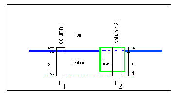
For the figure below, let's examine the
gravitational
force that pulls down on our imaginary cylinder that cuts through two
columns
in our tub.
Column 1 cuts through a column of air with length "a" and a column of water of length "b", for a total column length of "a + b".
Column 2 cuts through a column of ice with length "a+c", and a column of water with length "d". What are the forces acting on each column? We need to know the density and volume of the columns of air, water, and ice in each column to answer this question. The densities of ice and water are given above as 0.9 and 1.0 grams/cubic centimeter. The density of air for all intensive purposes is zero!
Since these are cylinders, the volume is simply equal to the height multiplied by the cross-sectional area of the cylinder. To simplify the problem, let's assign a cross-sectional area for each cylinder of 1.0 square centimeters. The volume is then simply 1 x height.
By Newton's second law, the force F1 acting equals the following:
g * [ (Density of air * a) + (Density of water * b)] = g * [(0 x a) + (1.0 grams/cubic centimeter * b centimeters * 1.0 square centimeters)]
or F1 = 1.0 * b * g
Similarly, the force F2 equals
g * [(density of ice * (a+c) ) + (density of water * d)] = g * [0.9*(a+c) + d ] or F2 = d * g + 0.9(a+c)*g
Now, what else do we know about F1 and F2?
Since
we know that the forces that pull down on every column of water are
equal
(if they weren't, the system would immediately readjust to make them
equal!),
we then know that F1 = F2. This is the key step - namely,
that we invoke Pascal's law that the pressure is equal everywhere at a
given depth in the fluid.
To solve the problem, we now choose a depth that corresponds exactly with the bottom of the ice and require pressures exerted by the overlying ice and/or water to be equal at that depth. In other words, imagine that the red-dashed line is positioned at the bottom of the ice. We can now write the following equivalence F1 = F2 = 1.0* b*g = 0.9(a+c)*g
Dividing by "g" gives 1.0*b = 0.9(a+c)
However, "b" = "c", so we can rewrite this as (1.0 - 0.9) * c = 0.9*a.
What are a and c ? C is the "root" that sticks down into the fluid - this "root" supports the material that stands above the water surface, which has a height of a.
For any two materials of different densities (with at least one acting as a fluid), we can write
(Density 1 - Density 2) * root = Density 2 * height above surface
where density 1 is greater than density 2.
A key point here is that it is the difference in
the
densities of the two materials that determines how deep a root must
extend
beneath the surface in order to support topography above the surface.
The equation above expresses the relationship
between the root and height of a material floating in a fluid and the
densities of the floating material and fluid.
ii) Evidence for mountain roots
Is there any evidence that mountains have such deep roots? Yes, there is abundant evidence from measurements of gravity over and near mountain ranges. Let's first digress briefly to the equation that specifies the force of gravitational attraction between two masses that are separated by a distance r.
F= G * m1 * m2 / (r * r)
Here, G is a constant (the universal gravitational constant), and m1 and m2 are the masses of objects 1 and 2. The equation thus indicates that as the distance between two objects increases, the gravitational attraction between them decreases as the square of the distance.
If the earth were perfectly spherical (i.e. no topography) and lacked any variation in density, then a mass that is hanging from a string (a plumb bob) would always point directly toward the earth's center. In the 18th century, French scientists on an expedition to South America to measure the distance of a degree of latitude noted that the great mass of the Andes mountain belt represented additional mass that would exert its own gravitational pull on a plumb bob that would deflect the plumb bob from "vertical" toward the mountain range. They thus estimated the mass of the mountain range and then predicted how much the vertical deflection should be. To their surprise, they found that the mass was not deflected as far as they predicted - they thus postulated that a "deficit" of mass beneath the mountain range had to exist. The mass deficit was a buoyant crustal root that extended down into the denser surrounding mantle.
Since the 18th century, many more gravity surveys of mountain ranges have been completed and they indicate that mountain ranges are often (but not always) accompanied by a mass deficit. For example, if one measures the gravitational attraction at many points in or above a mountain range and one then corrects the measured gravity signal for a variety of effects, one of which includes the contribution from topography above sea level (this is done by estimating the gravitational attraction that results from a given volume of material with a density equivalent to that of continental crust), the gravity field over a mountain range should be the same as the gravity field for flat regions that flank the mountain range. Instead, the corrected gravity field over the mountain range typically has values lower than the surrounding flat regions. This gravity "deficit" is evidence for a mass "deficit" beneath the mountain range - such a deficit can only occur if the density of material beneath the range is lower than the density of the material beneath the flat-lying regions. Thus, less dense or buoyant material underlies many mountains - this buoyant material is the "root" that is predicted to exist based on Archimede's principle.
Example: Gravity across the Tibetan Plateau, Himalayas
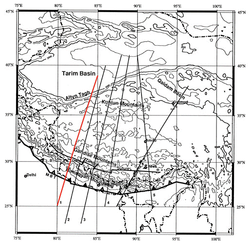
Figure 2: The red line in the map above shows a profile that crosses the Himalayan mountain range and Tibetan plateau of southern Eurasa. The following figure shows Bouguer gravity measurements along this profile. Adapted from Jin et al., May, 1996 Journal of Geophysical Research.
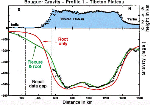
Figure 3: Dots in the upper panel show measurements of height along the profile shown in Figure 2. Note that the average height of the Tibetan plateau is about 5.5 km, or 18,200 feet. The distance across this nearly flat, but high plateau is 800 kilometers, or 500 miles. The highest topographic feature, about 6 km, is the high Himalayas, which are located at the southern edge of the Tibetan plateau. The lower panel shows Bouguer gravity measurements (black dots) and the gravity predicted by two simple models (described below). Note that the Bouguer gravity values are all less than zero, indicating that once gravity is "corrected" for the topography above sea-level (0 km), the gravity "anomaly" is negative, indicating a mass deficit at depth. The mass deficit indicates the existence of a low-density "root" beneath the mountain range. This root has a density lower than that of the underlying and surrounding mantle and thus provides a buoyant force that supports that Tibetan plateau. The Root only model assumes that the Bouguer gravity values are determined solely by the existence of the buoyant crust beneath the plateau. The Flexure & Root model assumes that the buoyant root is responsible for part of the gravity field, but that the strong lithosphere supports the mountain range/plateau, too. Adapted from Jin et al., May, 1996 Journal of Geophysical Research
Regarding Figure 3, READ THE CAPTION CAREFULLY . This gravity profile is a classic example of how one can use measurements at the earth's surface to learn about what exists deep beneath the surface. Note that the gravity values that are predicted by the Root only model fit the observed values reasonably well, but cannot account for all of the details in the observed gravity field! This implies that other physical processes are contributing to the local gravity field. An alternative model, "Flexure & Root", does a better job of fitting the observed gravity values. This model combines the buoyant forces exerted by a crustal root with the inherent strength of the earth's crust to explain how mountain ranges are supported.
Figure 4: Model of crust beneath the Tibetan plateau/Himalayan mountain range
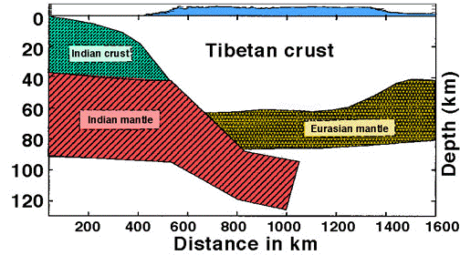
Note that the region designated "Tibetan
crust"
is the buoyant "root" that underlies the plateau, which is shown
as the blue shaded area above 0 km depth. Thus, a deep root lies
beneath
the plateau and this root has a density lower than that of the mantle
beneath
it and to its sides.
iii) Flexure of the lithosphere
Bouguer gravity fields across many mountain ranges clearly show evidence for mass deficits that are indicative of underlying and buoyant crustal roots. However, gravity anomalies associated with mountain ranges are rarely as large (meaning that Bouguer gravity values are never as "negative") as they should be if the mountain range were supported entirely by a buoyant root.This means that something besides the buoyant root has to be supporting mountain ranges. Not surprisingly, the crust itself helps to support topographic "loads".
For example, typical continental crust is approximately 40 km thick. Clearly, if one dumps a load of stone in the middle of the US Great Plains, the crust does not sink into the mantle until it achieves a buoyant root that is sufficient to support this new "topographic" load! Instead, the crust is strong enough to hold up the load without flexing down into the mantle (and thus developing a root). This is analogous to putting an eraser on a board - the board is strong enough to support the weight of the eraser without flexing. The crust thus has inherent strength that is capable of supporting small loads such as small volcanos without flexing down into the mantle. If the load gets large enough (a mountain range), the mountain range will be supported partly by the crust and partly by a buoyant root.
If you look at Figure 3 above, you will see exactly
this
situation. The "Root Only" model cannot fit the observed Bouguer
gravity. However, a model that assumes the existence of a
finite-strength
crust and a buoyant root, which act together to support the Tibetan
plateau,
fits the gravity values well.