Lecture 3
How do rocks deform ?
I. Stress
II. The geotherm
III. Folding and faulting
IV. How horizontally-directed plate motions cause vertical uplift
I. Forces and stress
Rocks change their shape and volume when they are subjected
to stress. Stresses are caused by forces that are exerted on the edges
or interior of a material. A wide variety of physical processes exert stresses
on rocks. For example, gravity constantly exerts downward stress on
all rocks. Temperature changes cause thermal expansion and contraction
that can cause rocks to fracture. Wetting and drying similarly can
induce or enhance rock fractures. On a large scale, horizontal plate
movement exerts lateral (horizontal) and vertical stresses on rocks. And
of course, the accumulation of thick layers of sediment can exert immense
downward pressure on rocks that are buried underneath.
Rocks exhibit two principal responses to stresses that are
exerted on them. They may deform like a brittle material, meaning that they fracture and fault. Alternatively,
at higher temperatures and pressures, many rocks flow in response to stress.
This type of deformation is referred to as ductile. Layers of sediment that are only weakly consolidated or
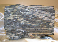
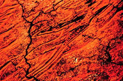
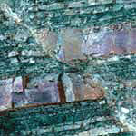
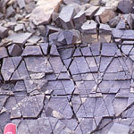
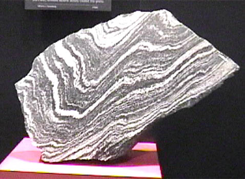
cemented might also flow when stressed. The images below exhibit the
contrast, with the leftmost image
showing jointing in rock and the rightmost image showing flow banding in
gneiss, a metamorphic rock.
II. The geotherm
The strong dependence of rock deformation on temperature is hardly surprising. For example, wax will fracture if it is chilled and then subjected to a sudden stress (such as dropping it on a hard floor). The same wax will bend like silly putty if heated to moderate temperatures and will flow like water if heated to high enough temperatures.Anyone who has been in a deep mine has experienced the
phenomenon of increasing temperatures with depth beneath the earth's surface.
The geotherm ranges from
roughly 10 degrees Centigrade per kilometer of depth in stable old continental
interiors to 30 degrees Centigrade per kilometer of depth along active plate
boundaries. (10 degrees Centigrade per km equals roughly 29 degrees
Fahrenheit per mile). So, for example, if the surface temperature of
rocks is about 60 degrees, then the rock temperature at a depth of one mile
is about 89 degrees in a continental interior.
The geotherm is important for several reasons. On
a practical level, some gold mines reach depths of 3.9 kilometers (2.4
miles) and have geotherms that average 30 degrees C per kilometer. The
implied temperature at the deepest levels of the mine (3.9 km x 30 degrees
C per km) is 117 degrees C + 20 C (the surface temperature) = 137 C.
For comparison, water boils at a temperature of 100 C ! Air conditioning
enables work in these deep mines; however, even the chilled air has a temperature
of 90 degrees Fahrenheit and has typically humidities of 100%.
The common mineral quartz maks a transition from brittle
to ductile deformation at temperatures of roughly 350 Centigrade when water
is present. If we assume a geotherm of 30 C per km along an active plate
boundary, then quartz-rich rocks will, in general, fracture (fault) at depths
above 11-12 km (=350 C/ 30 C per km), but will flow at lower depths. We
should thus observe a transition from faulting to ductile deformation at
depths of roughly 10-20 km, depending on the geotherm that applies for a
particular region.
III. Folding and faulting
Let's learn about the most spectacular form of ductile deformation, namely, rock folding.
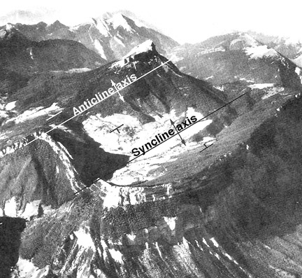
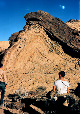
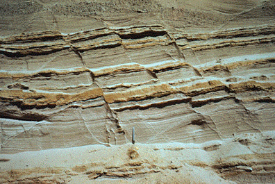
Folding - ductile behavior in which planar (flat) layers of rock bend in response to stress.Depending on whether the hinge of a fold (i.e. the point of sharpest curvature) points up, down, or to the side, a fold is respectively called an anticline, a syncline, or a recumbent fold.
Here is an example of an anticline and syncline. Notice that the fault that offsets the bedding at the left edge of the synclinal trough.
Is the following mountain-scale fold an anticline or syncline?
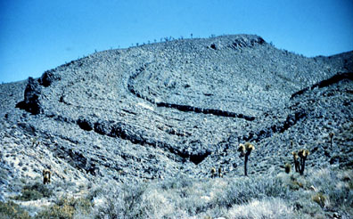
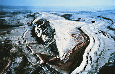
Satellite image of eroded surface intersected by plunging folds
Sheep Mountain, Big Horn basin, Wyoming
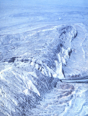
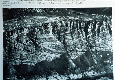
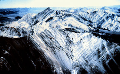
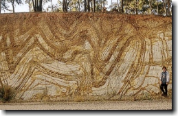
Please examine the additional images of folds below to get a good idea of the variety of fold types and the variety of scales at which folding occurs.
Recumbent fold. Note river at bottom of the photograph.
Mountain-scale syncline.
Anticline
Recumbent fold
Folds in sedimentary rocks, Australia
Folds formed during metamorphism
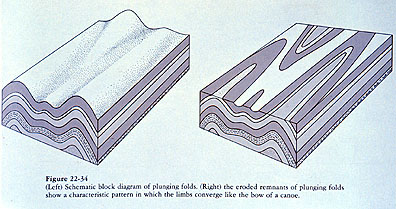
Folds in 3-dimensionsThe diagram below shows how a fold whose fold axis plunges into the earth (left half of diagram) appears when it is eroded and the folded rock layers are exposed (right half of diagram).
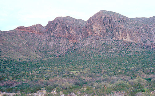
Compare the idealized "plunging fold" shown above to the aerial photos and satellite image below. Are you convinced that the images below represent the surface expression of plunging folds that are partially eroded?
Sheep Mountain, Wyoming. Photo courtesy of Lou Maher, "Geology by Light Plane"
Sheep Mountain, Wyoming. Photo courtesy of Lou Maher, "Geology by Light Plane"
Faulting - brittle behavior in which a rock responds to stress by developing one or more fractures. Deformation of the rock concentrates along the fractures. Slip along faults frequently occurs through sudden ruptures (earthquakes).
Normal faults in volcanic ashes and paleo-soils, El Salvador, photo by Chuck DeMets
Before seeing some examples of faults, let's first review some simple terminology.
A foot wall is the underlying surface of a fault plane.
A hanging wall is the overlying surface of a fault plane.
The foot wall thus consists of the rocks that lie beneath a fault surface - one could stand on the foot wall of a fault if the hanging wall rocks were removed. Similarly, if one could somehow remove the foot wall rocks, one would have to "hang" from the hanging wall rocks.Faults can be grouped into several categories, depending on their geometry and the type of motion that occurs across them. We will consider the following three types of faults:
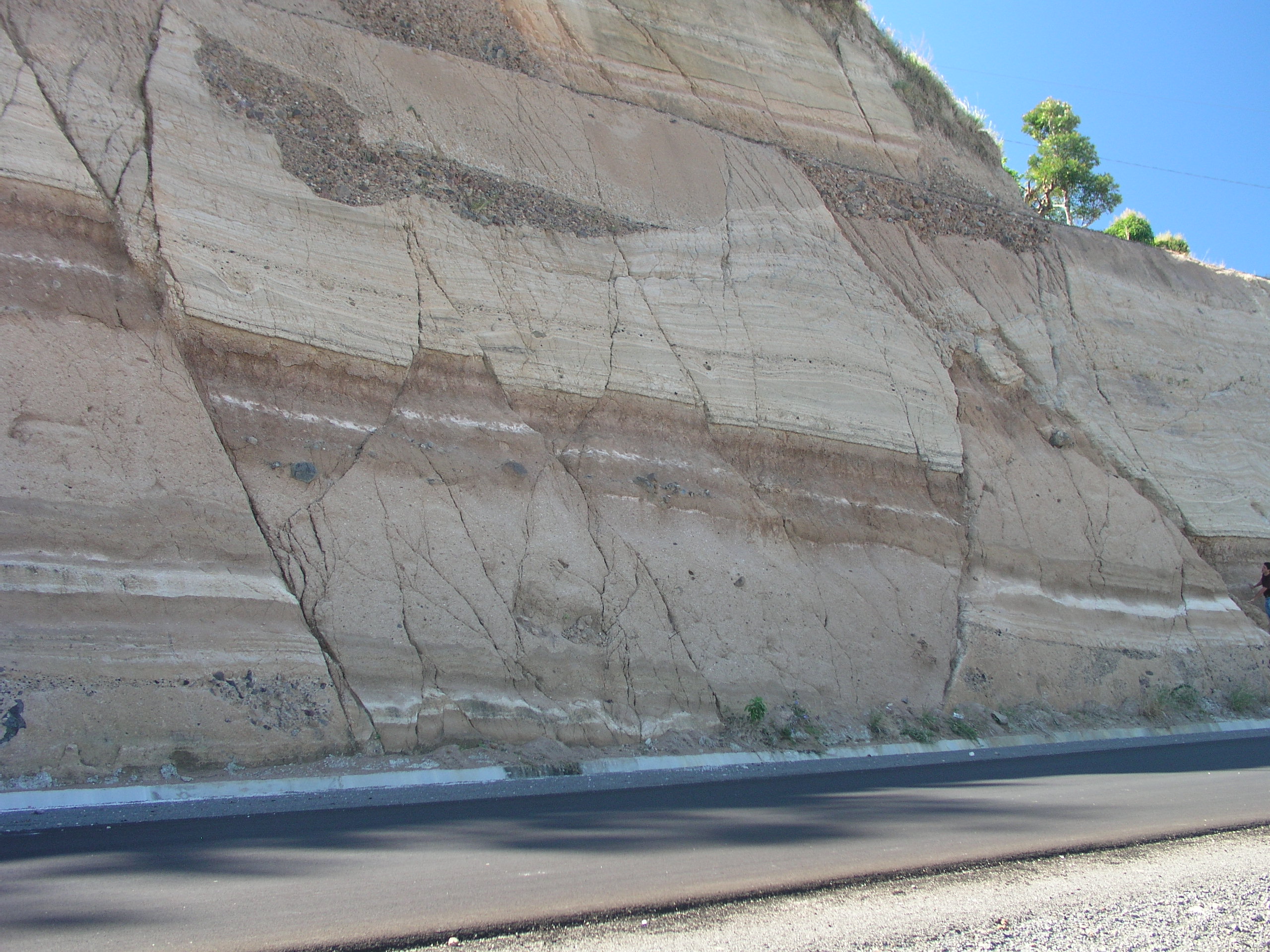
Note that faulting is not the same as jointing, which are fractures along which no slip has occurred. (See the first image in this lecture for an excellent example of rock joints).
- Reverse faults - hanging wall rocks slide upward along the fault surface and thus thrust over the foot wall rocks. A thrust fault is a reverse fault that is inclined at angles of less than 45 degrees from horizontal.
- Normal faults - hanging wall rocks slide downward along the fault surface, giving the appearance that the foot wall rocks are sliding upward.
- Strike-slip faults - lithosphere on either side of the fault moves horizontally in a direction parallel to the fault.
Examples of each of the three types of faulting are shown below.
Normal faults
Normal faults in layered sedimentary rocks. See rock hammer for scale near bottom of photo.
Reverse fault
Thrust fault. Reddish rocks are in the hanging wall and grayish rocks are in the foot wall.
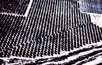
Rows of orange trees offset by 20 feet during 1940 Imperial Valley earthquake in southern California. Can you find the likely trace of the fault and determine whether slip along the fault was to the right or the left ?
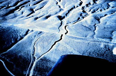
Offset of stream bed along San Andreas fault in central California. Where is the trace of the fault and what is the sense of slip ?
Although examples of normal, reverse, and strike-slip faults can be found along any type of plate boundary (divergent, convergent, transcurrent), faulting along a given plate boundary is usually dominated by one particular fault type.Thrust faults are characteristic of convergent plate boundaries, and provide a mechanism for creating mountain ranges (i.e. for accommodating crustal thickening).
Normal faults are more typical of extensional environments (divergent plate boundaries) such as continental rifts and seafloor spreading centers.
Strike-slip faults are almost always found along seafloor spreading centers (transform faults) and also frequently form along plate boundaries where plate motion is oblique (at an angle to) the plate boundary.
II. Building Mountains
Recall that as plates move around the earth's surface, they exert powerful lateral forces on rocks. The response of the crust to those forces gives rise to deformation on a large scale, particularly along plate boundaries. For example, dozens or hundreds of large-scale faults can form in zones of plate convergence, resulting in a broad and high mountain belt. Here is a list of geologic processes that can result in mountain building.
- Crustal shortening/thickening in response to convergence of a subducting plate.
- Continental collision
- Uplift of sediments accreted by subduction
- Volcanism
- "Corner" accretion/uplift due to along-trench rafting of terrane
- Heating or cooling of lithosphere by the underlying mantle (and hence uplift or subsidence) .
- Crustal extension
Developing an understanding of each of these mechanisms for uplift will require much of the remainder of the course. For the remainder of this lecture, let's review mountain uplift as a consequence of horizontal plate displacements.
Geometrically, if two plates are colliding, they can respond as follows:
- One plate can subduct into the mantle.
- One or both plates can undergo shortening and hence uplift and crustal thickening.
- One or both plates can undergo lateral extrusion (i.e. part of the plate escapes the collision zone by extruding sidewards).
Let's consider the first two cases.
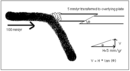
Suppose an oceanic plate converges with a continental plate. The oceanic plate, being more dense, subducts into the mantle. If ALL convergence (100%) is accommodated by subduction, the overlying continent will remain undeformed and should undergo no net uplift (although topography will undoubtedly develop as arc volcanos appear). Suppose that not all convergence is accommodated by subduction and a few percent of the convergence instead causes the upper plate to shorten. How much uplift is implied?
For 100 millimeters per year of convergence (a typical plate velocity), if 5% is accommodated by long-term shortening of the overlying plate, then the overlying plate will shorten at a rate of roughly 5 millimeters per year
Geometrically, the 5 mm/yr of horizontal shortening translates into vertical motion as shown above, with the only dependence being on the dip of the fault along which the continent is shortening. For low angle faults (10 degrees), uplift will occur at rates of about 1 mm/yr (1 kilometer per million years). Over 5 million years, this amounts to uplift of 5 kilometers or 3 miles (15,900 feet). Over the same period, the two plates will have converged some 5 million years x 100 kilometers per million years or 500 km. The total uplift then is only a small percentage, 1%, of the total horizontal motion.
The main point of this simple exercise is to demonstrate that even if a continent accommodates only a small percentage of convergence between itself and an oceanic plate, substantial uplift can result after the passage of time.
Continent-continent collisions are not usually accompanied by subduction because both plates are too buoyant to be thrust deeply into the mantle. The amount of crustal thickening and uplift in such a collision can thus be much greater than for an ocean-continent collision. For example, over the past 40 million years, continental India has driven northward into continental Eurasia across the Himalayan mountain belt at a rate of about 40-50 millimeters per year. If you work it out, this implies that the two plates have somehow shortened by more than 1500 kilometers (about 900 miles) across the Himalayas. Since subduction is not occurring, the shortening has been accommodated by mountain building and lateral escape.
Factors that complicate calculations of total uplift
The simple geometric exercise above is designed to give you a feeling for the magnitudes of vertical uplift that might accompany horizontal motion. Plate convergence of hundreds or even a thousand kilometers or more over millions of years might be accompanied by only several kilometers of uplift. This uplift, while spectacular to the eye, is merely a small part of the displacement "budget", which is largely dominated by horizontal motion.
The geometric exercise ignores many important aspects of mountain building and cannot be used as a technique for predicting total topography given total horizontal motion. Why is this the case?
- Fault dips are rarely well known and faults are often curved, with their dips increasing toward the surface.
- Erosion/mass wasting removes material from the upper reaches of uplifting regions, sometimes nearly as quickly as the region is going up!
- Vertical uplift must fight the downward pull of gravity. In extreme cases, no amount of horizontal convergence is capable of causing further uplift.
- Crustal uplift often coincides with subsidence through a process called isostatic adjustment, which we will study later in the course. This is analogous to climbing into a boat, which sinks lower into the water once your weight is added to that of the boat. Your net height above the water surface is equal to your height on land minus the amount the boat sinks. Continents similarly sink into the underlying mantle when substantial topographic loads are added to their surface.
- Lateral escape of crust sometimes accommodates a significant fraction of plate convergence, leaving less available for inducing vertical uplift.
- Uplift can occur simultaneously or sequentially along many faults that exist in a broad zone of deformation between two converging plates. Relating the total horizontal convergence to total "shortening" then requires measurements across many faults.