In this class, we will study the natural processes that build and destroy
mountains over geologic time. Mountains represent some of the longest-lived
features of Earth's surface, with lifetimes that sometimes exceed 100
million years. They profoundly influence local and regional
climate in some areas of the world, and frequently are biological "islands"
jutting into the atmosphere, where rare or unique species evolve and are preserved.
Although geologists have studied mountain ranges for centuries, a thorough
understanding of the causes and mechanisms of their genesis awaited the advent
of the theory of plate tectonics in the 1960s. Beyond the geologic focus
of this class, it is important to understand that mountains have profoundly
influenced the evolution of humans and non-human species. Roughly 20%
of Earth's continents are mountainous. In addition, roughly 10%
of the world's peoples live in mountains. Before the advent of modern air
travel, mountains presented significant geographic barriers to migration,
trade, and military conquest. As modern transportation has facilitated
access to once-remote mountainous areas, their vast mineral, water, and recreational
resources have become increasingly exploited. Poorly planned use of
mountain resources frequently poses adverse consequences to unique mountain
ecosystems and cultures. Mountain-top removal in West Virginia for
the purpose of mining coal within or beneath mountains is perhaps the most
extreme example of negative exploitation of mountain resources.
As a necessary element in this course, you will need to become familiar with Earth's geography and its external and internal structure. In addition, you'll need to become familiar with various geologic terms. Many terms will be defined in a Web-based glossary that can be accessed by clicking on highlighted terms.
Mountain - any natural topographic feature that rises significantly above the surrounding landscape. "Significantly" implies thousands of feet.
IIa. Geography and Earth Structure
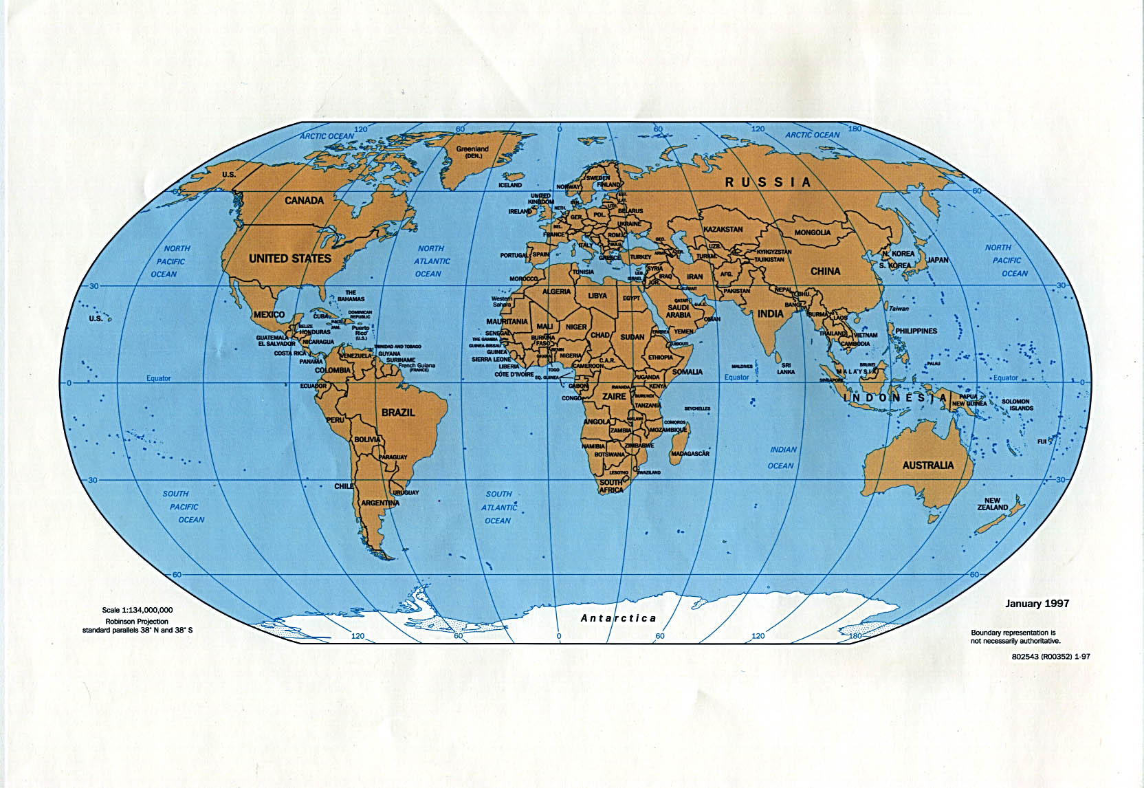
Let's review Earth's first-order geography, consisting of the principal
ocean basins and land masses.
Click on the image to the right for a large map of the surface and familiarize
yourself with the locations of the four major ocean basins (Pacific,
Indian, Atlantic, and Arctic) and the six major land masses (North
and South America, Antarctica, Africa, IndoEurasia, and Australia).
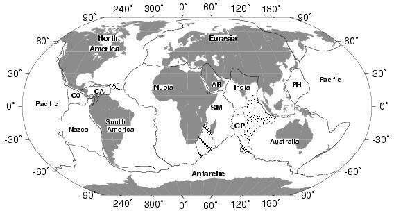
A more meaningful division of Earth's surface from the geological perspective
is its division into a series of major, internally rigid tectonic plates.
Plate names (some are abbreviated):
Antarctic, Arabian (AR), Australian, Caribbean (CA), Cocos (CO), Capricorn
(CP), Eurasian, Indian, Nazca, North American, Nubian, Pacific, Philippine
(PH), South American, Somalian (SM) plates. Several smaller plates whose
locations are NOT shown include the Juan de Fuca, Rivera, and Scotia plates.
IIb. Earth's interior
Over the past century, seismologists have employed techniques similar
to those now used for medical CAT scans to image Earth's interior.
To do so, seismologists use the travel times of seismic waves that bounce
around Earth's interior following an earthquake. At present, millions
of travel times from hundreds of thousands of earthquakes have been used
to image the planetary interior. The major divisions of the interior were
known by the 1940s, although our understanding is constantly being refined.
The interior consists of an inner and outer core, the mantle, and the crust.
Further details about each are given below.
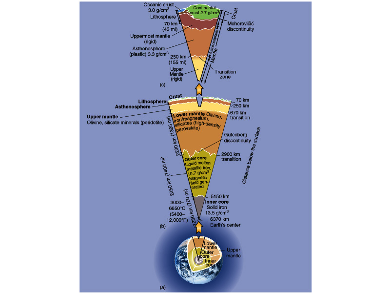
Inner core - primarily iron (Fe), with some nickel (~5%) and additional unknown elements in trace amounts (possibly sulfur, oxygen, or hydrogen). The inner core is solid and some researchers postulate that it might be a single gigantic iron crystal! The radius of the inner core is 1220 kilometers, and its temperature does not exceed 8,100-14,400 degrees Fahrenheit.
Outer core - The outer core is a 2260 km-thick shell wrapped around the inner core. It consists mainly of iron (~90%) with significant amounts of other elements, possibly sulfur, oxygen, or hydrogen. Strangely enough, seismic waves that penetrate the outer core demonstrate that it is fluid (molten iron), in contrast to the solid but hotter inner core. This is widely believed to result from the existence of significant amounts of sulfur, oxygen, or hydrogen, which depress the melting point of the outer core's material relative to the melting point of the inner core, which is believed to have only very small amounts of these same elements.
Mantle - The mantle is a 2890-km-thick shell wrapped around the outer core. It makes up 84% of Earth's volume. On short time scales (seconds to minutes), the mantle acts like a solid, but on longer time scales (years and longer), it flows like a fluid. The temperature at the base of the mantle is 3000-4000 degrees Centigrade, and decreases to roughly 1300 C at the base of the crust. Silicate rocks make up the majority of the mantle - these are rocks with mineral structures that include lots of silicon (Si) and oxygen (O). Earth's mantle has at least two well-defined internal layers that are defined by sudden changes in the velocities of seismic waves that travel through the mantle, one at 660-670 km depth and the other at 410-420 km depth. These are believed to represent boundaries where minerals in the mantle undergo rearrangements of their crystal structure to stable configurations at the pressures and temperatures at that depth.
Crust - Earth's crust is a thin shell 5-100 km-thick on top of the mantle. Beneath oceans, crustal thicknesses average 6 kilometers and crustal composition consists dominantly of basaltic and gabbroic rocks, which are rich in iron and have less silicon and oxygen on average than continental rocks. Continental crustal is typically 25-70 km thick, with an average of roughly 40 km. The upper part of continental crust is granitic (rich in silicon and oxygen relative to oceanic crust) and the lower part of continental crust has a composition similar to that of oceanic crust.
The division between crust and mantle is defined by a sudden change in the velocities of seismic waves - this dividing line is called the Mohorovic discontinuity or Moho for short. Beneath the Moho, seismic waves travel at more than 8000 meters per second; above the Moho, they travel 5000-8000 meters per second.
Layers in Earth can also be defined by the manner in which material at a given depth responds to forces that are exerted on it.
Lithosphere- the layer of Earth that responds to stress by bending and ultimately, breaking. When subjected to stress, the lithosphere tends to rupture along pre-existing faults (weaknesses), thereby giving rise to earthquakes . The lithosphere typically includes the crust and part of the upper mantle.
Asthenosphere - beneath the lithosphere, materials show a more plastic response to stress. If you could hold some asthenosphere in your hands and squeeze it, it would flow in a manner similar to silly putty.
Overall, the approximate distance (radius) from Earth's surface to its center is 6370 kilometers, although the precise distance depends on one's location. The polar radius is smaller than the equatorial radius, implying that Earth's shape deviates from a perfect sphere (it bulges slightly at the equator). The equivalent radius in miles is roughly 4000 miles. This implies that the approximate distance around the globe is 2 x PI x 4000 miles = 25,000 miles, roughly the distance that a busy driver will drive his or her car in one year.
Earth's depth-dependent structure arises from its need to transport heat from its hot interior to its cool surface. The temperature differential between the core and the surface is after all approximately 10,000 Fahrenheit, with the average surface temperature being only somewhat above freezing.
The primary mode by which heat is transported to the surface is through convection. Convection is defined as circulation of fluid due to contrasts in its density. Density contrasts are often caused by temperature differences within a fluid (or other material). For example, most materials become more buoyant (i.e. less dense) when they are heated, with water and ice being the prominent exception to this rule. Thus, material in the mantle that is heated at the base of the outer core will rise, whereas mantle material near the surface that has shed its heat to the overlying crust will sink. Cells of sinking and rising material thus carry heat from the interior to the surface.
Earth's geologically active surface represents a response to its actively convecting interior. The relatively fluid interior is, in effect, an enormous heat engine that transports heat from the hot core to the cool surface. Plate tectonics and volcanism are two important surface processes that result from outward convection of heat from Earth's interior.
IIc. Hypsometry - The bimodal distribution of surface heights
The remarkable contrast between the heights of two domains of the crust, oceanic crust and continental crust, is a first-order feature of Earth's surface.
The majority (71%) of Earth's surface lies beneath sea level at average depths of 3-3.5 km (9,900-11,600 feet). The vast majority of the rest of the surface lies at heights of 0.85 km (2900 feet) above sea level.
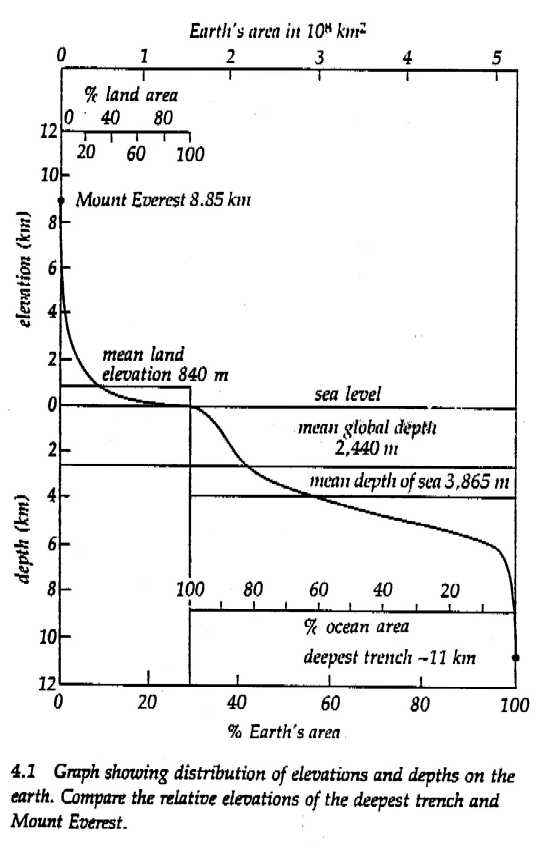
Why does this contrast exist? Continental crust, which has an average density of 2800 kilograms per cubic meter, is not as dense as oceanic crust, which has an average density of 2900 kilograms per cubic meter. Neither is as dense as the underlying mantle, which has a density of 3300 kilograms per cubic meter. Hence, both continental and oceanic crust "float" on the mantle. Oceanic crust floats lower in the mantle than does continental crust because continental crust is more buoyant. We shall return to this concept later in the course.
The remarkable bimodal distribution (a distribution with two peaks) of surface heights cannot be ignored when attempting to understand the geology of Earth's surface. Ultimately, this bimodal distribution relates to the theory of plate tectonics, which will be the subject of the next lecture.